NASA: The Shapes that Lavas Take - Part 2 - Russia - Kamchatka - 12.06.13
Posted by Ricardo Marcenaro | Posted in NASA: The Shapes that Lavas Take - Part 2 - Russia - Kamchatka - 12.06.13 | Posted on 17:40
Read part 1 of this story to see an example of a lava dome created by highly viscous lava.
Streams of molten rock that ooze from gaps or vents in the Earth’s surface are called lava flows,
and they can pose a hazard to everything in their paths. These rivers
of rock can take many shapes and move at very different rates depending
on the viscosity of the magma, the slope of the land, and the rate of an
eruption.
While viscous lava flows
are defined by steep flow fronts and pressure ridges, low-viscosity
lavas tend to move faster and create longer, narrower shapes. They also
tend to have smaller flow fronts and levee-like structure along their
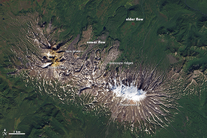
edges. Many characteristics of a low-viscosity lava flow are visible in
this image of Zhupanovsky and Dzenzursky volcanoes on Russia’s Kamchatka Peninsula. The image was acquired by the Operational Land Imager (OLI) on the Landsat 8 satellite on September 9, 2013.
In the image, younger lava flows appear grey, while older flows are
covered by green vegetation. The exact ages of the flows are unclear,
but the eruptions that produced them likely occurred during the past few
thousand years. Distinctive lava levees
are visible along the edges of many of the younger flows. These
features form as lava cools and hardens along the edges or top of a flow
while the center of a flow still advances.
In comparison to the Chao dacite
in Chile (the product of viscous lava), the flows at Zhupanovsky and
Dzenzursky are much narrower and longer. They have smaller flow fronts
(10 to 30 meters tall) in comparison to the sheer 400-meter cliffs at
Chao, as well as more prominent lava levees
along the edges. Like Chao, the flows shown above have pressure ridges
caused by the compression of the cooling top of the lava as the flow
advanced.
References
- Bazanova, L. & Dirksen, O. (2006) Eruptive history of Zhupanovsky volcano as a base for hazard evaluation. Geophysical Research Abstracts, (8), 07335.
- Oregon State University Chao Accessed November 20, 2013.
- U.S. Geological Survey Lava Flows and their Effects. Accessed November 20, 2013.
- Volcano World How fast does lava flow? Accessed November 20, 2013.
- Wired Identifying Lava Flow Features. Accessed November 20, 20013.
NASA Earth Observatory images by Robert Simmon, using Landsat 8 data from the USGS Earth Explorer. Caption by Erik Klemetti (Denison University) and Adam Voiland (Earth Observatory).
- Instrument:
- Landsat 8 - OLI
NASA: The Shapes that Lavas Take - Part 2 - Russia - Kamchatka - 12.06.13
Ricardo M Marcenaro - Facebook
Blogs of The Solitary Dog:
solitary dog sculptor:
http://byricardomarcenaro.blogspot.com
Solitary Dog Sculptor I:
http://byricardomarcenaroi.blogspot.com
Para:
comunicarse conmigo,
enviar materiales para publicar,
propuestas:
marcenaroescultor@gmail.com
For:
contact me,
submit materials for publication,
proposals:
marcenaroescultor@gmail.com
My blogs are an open house to all cultures, religions and countries. Be a follower if you like it, with this action you are building a new culture of tolerance, open mind and heart for peace, love and human respect.
Thanks :)
Mis blogs son una casa abierta a todas las culturas, religiones y países. Se un seguidor si quieres, con esta acción usted está construyendo una nueva cultura de la tolerancia, la mente y el corazón abiertos para la paz, el amor y el respeto humano.
Gracias :)


Comments (0)
Publicar un comentario