
NASA: Russia - Avachinsky Volcano. Kamchatka Peninsula - Jordan - Amman
Posted by Ricardo Marcenaro | Posted in NASA: Russia - Avachinsky Volcano. Kamchatka Peninsula - Jordan - Amman | Posted on 19:43
Open your mind, your heart to other cultures
Abra su mente, su corazón a otras culturas
You will be a better person
Usted será una mejor persona
RM
Abra su mente, su corazón a otras culturas
You will be a better person
Usted será una mejor persona
RM
Avachinsky Volcano. Kamchatka Peninsula
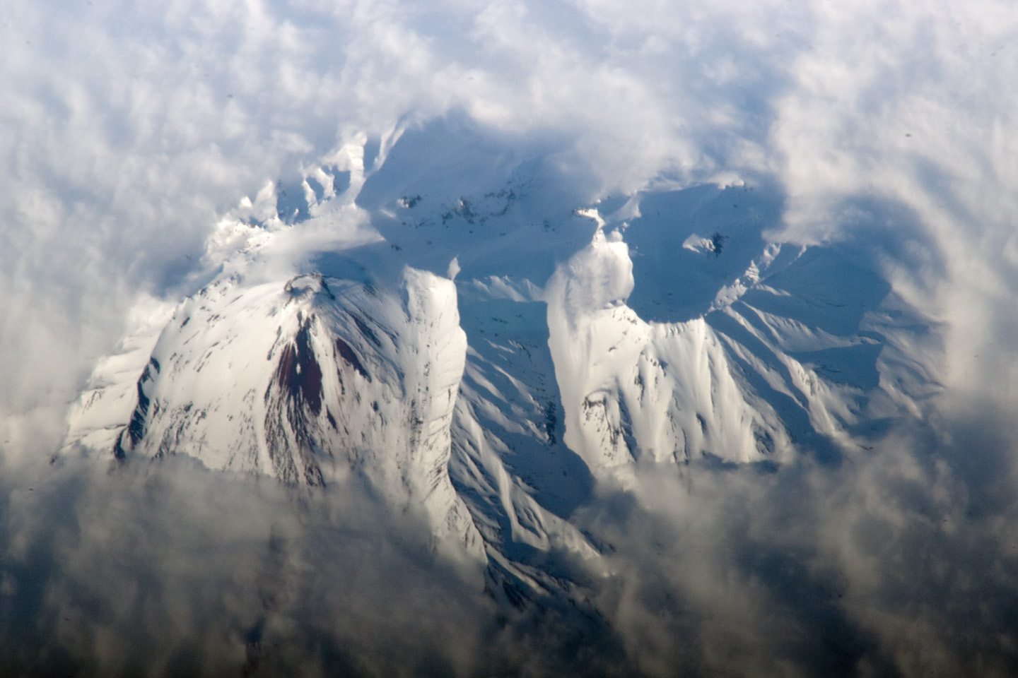
The Kamchatka Peninsula of Russia, located along the Pacific “ring of fire,” includes more than 100 volcanoes. While most of these volcanoes are not actively erupting, many are considered dangerous due to their eruptive history and their proximity to population centers and air travel corridors. This astronaut photograph highlights the summit crater and snow-covered slopes of the Avachinsky stratovolcano as it pokes above a surrounding cloud deck.
The 2,741 meter (8,993 foot) high Avachinsky volcano has an extensive historical and geological record of eruptions. The latest activity occurred in 2008.
The large city of Petropavlovsk, Kamchatka, is located approximately 25 kilometers (15 miles) to the southwest and is built over approximately 30,000–40,000 year old debris deposits from an avalanche that originated at Avachinsky—suggesting that the city may be at risk from a similar hazard in the future. To the southeast (image right), the large breached crater of Kozelsky Volcano is also visible above the clouds. Kozelsky is a parasitic cone, formed by the eruption of material from vents along the flank of Avachinsky.
The topography of the volcanoes is accentuated by shadows caused by the relatively low sun angle, and by the oblique viewing angle. Oblique images are taken looking outwards from the International Space Station, rather than the “straight down” (or nadir) view typical of most Earth-observing sensors.
Astronaut photograph ISS027-E-20395 was acquired on May 2, 2011, with a Nikon D2Xs digital camera using an 800 mm lens, and is provided by the ISS Crew Earth Observations experiment and Image Science & Analysis Laboratory, Johnson Space Center. The image was taken by the Expedition 27 crew. The image has been cropped and enhanced to improve contrast. Lens artifacts have been removed. The International Space Station Program supports the laboratory as part of the ISS National Lab to help astronauts take pictures of Earth that will be of the greatest value to scientists and the public, and to make those images freely available on the Internet. Additional images taken by astronauts and cosmonauts can be viewed at the NASA/JSC Gateway to Astronaut Photography of Earth. Caption by William L. Stefanov, NASA-JSC.
- Instrument:
- ISS - Digital Camera
Jordan - Amman
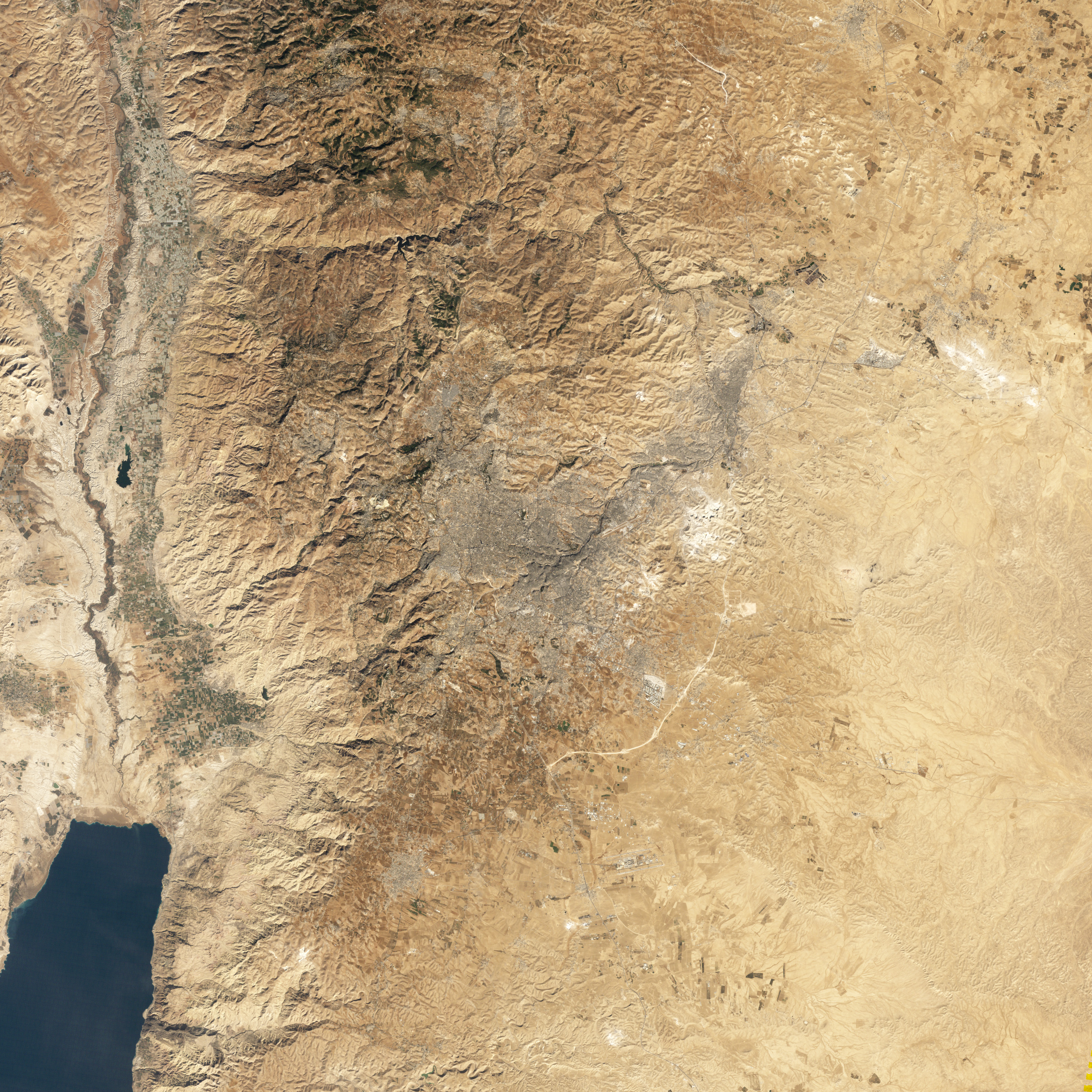
About 9,000 years ago, a settlement was founded in an area of rolling hills between the fertile Jordan River Valley to the west and desert in the east. Along the banks of the Wadi Amman and its tributaries, this settlement has alternately flourished and declined, but has remained continuously inhabited to the present day.
NASA’s Landsat 5 satellite captured this natural-color image of Amman, Jordan, on December 3, 2010. The city forms a rough V shape of gray. West of the city, the terrain is more rugged, with small valleys extending toward the Jordan River. Part of the Dead Sea appears southwest of Amman, and agricultural fields in the Jordan River Valley appear west of town. East of the city, the land is flatter.
The uneven terrain in this region is composed of sedimentary rocks—chalk, chert, limestone, and marl—likely deposited when this slab of Earth's crust was underwater. The rocks in this region date from the Cenomanian Stage to the Paleocene Epoch, or roughly 95 million to 55 million years ago.
Limestone and chert are good for holding water in aquifers, making them a valuable resource to the country. Less than 5 percent of Jordan’s land is arable, and just over 1 percent supports permanent crops. Fresh water is scarce, and drought and desertification pose perennial threats. A relatively moist area compared the deserts of eastern Jordan, Amman is home to more than 1 million of the country’s estimated 6 million residents.
-
References
- Jordan Tourism Board. (2010). Amman. Accessed April 21, 2011.
- CIA World Factbook. (2011, April 6). Jordan. Accessed April 21, 2011.U.S. Geological Survey. (1998). Overview of Middle East Water Resources. Accessed April 21, 2011.
- Encyclopedia Britannica. (2011). Amman. Accessed April 21, 2011.
NASA Earth Observatory image created by Jesse Allen, using Landsat data provided by the United States Geological Survey. Caption by Michon Scott.
- Instrument:
- Landsat 5 - TM
NASA: Russia - Avachinsky Volcano. Kamchatka Peninsula - Jordan - Amman
You have an alphabetical guide in the foot of the page in the blog: solitary dog sculptor
In the blog: Solitary Dog Sculptor I, the alphabetical guide is on the right side of the page
Thanks
Usted tiene una guía alfabética al pie de la página en el blog: solitary dog sculptor
En el blog: Solitary Dog Sculptor I, la guia alfabética está en el costado derecho de la página
Gracias
Ricardo M Marcenaro - Facebook
Blogs in operation of The Solitary Dog:
solitary dog sculptor:
http://byricardomarcenaro.blogspot.com
Solitary Dog Sculptor I:
http://byricardomarcenaroi.blogspot.com
Para:
comunicarse conmigo,
enviar materiales para publicar,
propuestas comerciales:
marcenaroescultor@gmail.com
For:
contact me,
submit materials for publication,
commercial proposals:
marcenaroescultor@gmail.com
Diario La Nación
Argentina
Cuenta Comentarista en el Foro:
Capiscum
My blogs are an open house to all cultures, religions and countries. Be a follower if you like it, with this action you are building a new culture of tolerance, open mind and heart for peace, love and human respect.
Thanks :)
Mis blogs son una casa abierta a todas las culturas, religiones y países. Se un seguidor si quieres, con esta acción usted está construyendo una nueva cultura de la tolerancia, la mente y el corazón abiertos para la paz, el amor y el respeto humano.
Gracias :)

Comments (0)
Publicar un comentario