
NASA: United States - Valles Caldera. New Mexico
Posted by Ricardo Marcenaro | Posted in NASA: United States - Valles Caldera. New Mexico | Posted on 20:10
Open your mind, your heart to other cultures
Abra su mente, su corazón a otras culturas
You will be a better person
Usted será una mejor persona
RM
Abra su mente, su corazón a otras culturas
You will be a better person
Usted será una mejor persona
RM
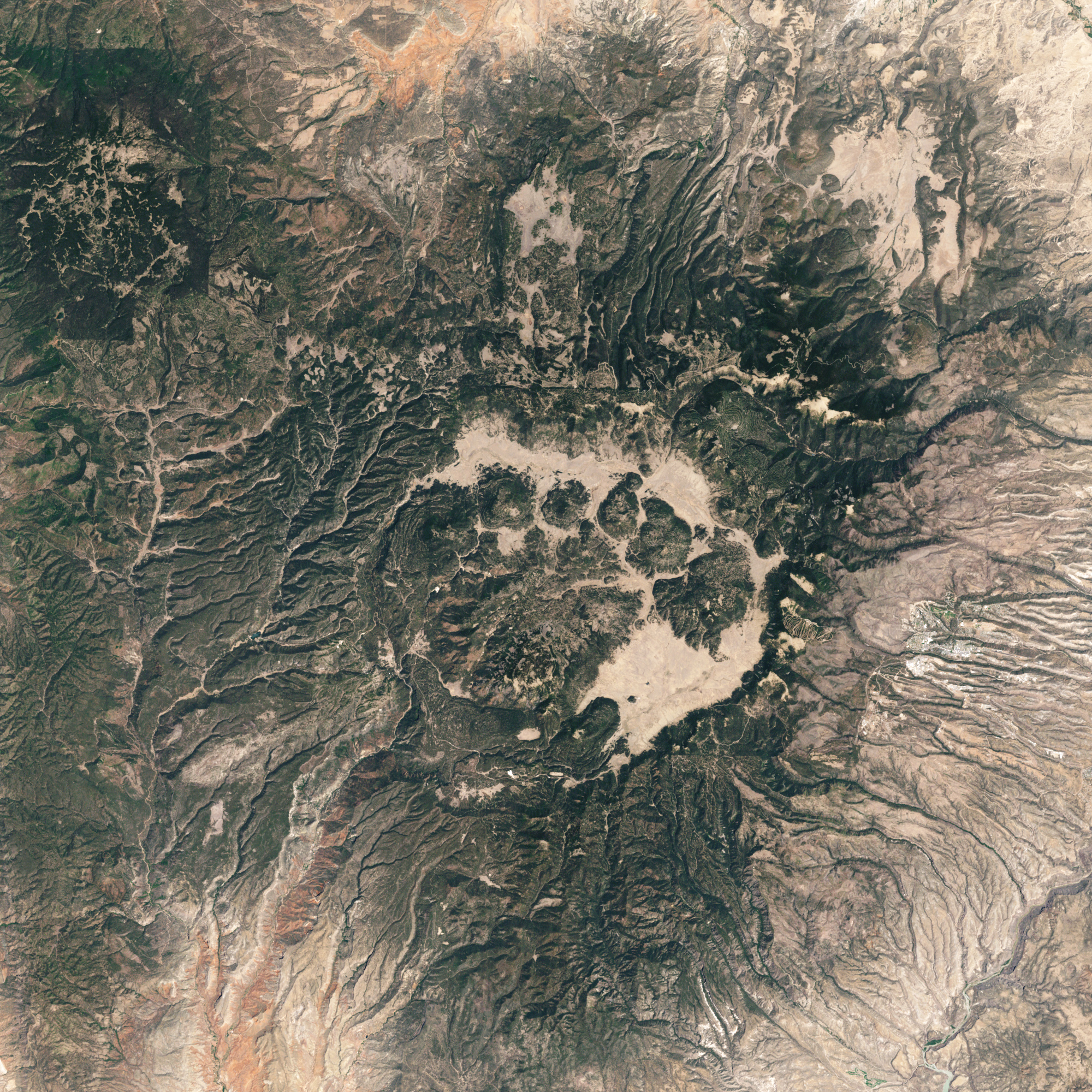
Spanning about 22 kilometers (14 miles), Valles Caldera in New Mexico was formed from the collapse of a magma chamber following ancient volcanic eruptions. The Enhanced Thematic Mapper Plus on Landsat 7 satellite captured this natural-color image of the area on May 22, 2002. Plants have colonized parts of the caldera, which is surrounded by a network of valleys. The city of Los Alamos lies to the east.
Valles Caldera is a complex formation resulting from two high-volume eruptions that occurred during the Pleistocene Epoch. Eruptions about 1.7 million and 1.2 million years ago pushed up magma that was rich with water and granite. When the magma broke through overlying rock layers, its water content turned to steam, driving powerful eruptions that buried the surrounding area in layers of volcanic ash—hundreds of meters thick in some places.
As ash and steam billowed overhead, magma under the surface dwindled. In the eruption 1.2 million years ago, a giant rock plug descended into the magma chamber, leaving steep rock walls around its perimeter. Landslides toward the chamber quickly followed. Over thousands of years, however, the caldera floor slowly rose. Today, hot springs and fumaroles persist at Valles Caldera.
The volcanic ash that sprayed over the landscape during the Pleistocene later hardened into the Bandelier Tuff. Parts of this porous volcanic rock later became home to Ancestral Pueblo people who carved cavates. Some of these ancient dwellings are now preserved at Bandelier National Monument.
-
References
- Global Volcanism Program. (n.d.) Valles Caldera. Smithsonian Institution. Accessed May 19, 2011.
- Treiman, A. (2003, September 6). Valles Grande Caldera – Geologic History. Accessed May 19, 2011.
- U.S. National Park Service. (2011, May 5). Bandelier National Monument. Accessed May 19, 2011.
NASA Earth Observatory image created by Jesse Allen and Robert Simmon, using Landsat data provided by the United States Geological Survey. Caption by Michon Scott.
- Instrument:
- Landsat 7 - ETM+
NASA: United States - Valles Caldera. New Mexico
You have an alphabetical guide in the foot of the page in the blog: solitary dog sculptor
In the blog: Solitary Dog Sculptor I, the alphabetical guide is on the right side of the page
Thanks
Usted tiene una guía alfabética al pie de la página en el blog: solitary dog sculptor
En el blog: Solitary Dog Sculptor I, la guia alfabética está en el costado derecho de la página
Gracias
Ricardo M Marcenaro - Facebook
Blogs in operation of The Solitary Dog:
solitary dog sculptor:
http://byricardomarcenaro.blogspot.com
Solitary Dog Sculptor I:
http://byricardomarcenaroi.blogspot.com
Para:
comunicarse conmigo,
enviar materiales para publicar,
propuestas comerciales:
marcenaroescultor@gmail.com
For:
contact me,
submit materials for publication,
commercial proposals:
marcenaroescultor@gmail.com
Diario La Nación
Argentina
Cuenta Comentarista en el Foro:
Capiscum
My blogs are an open house to all cultures, religions and countries. Be a follower if you like it, with this action you are building a new culture of tolerance, open mind and heart for peace, love and human respect.
Thanks :)
Mis blogs son una casa abierta a todas las culturas, religiones y países. Se un seguidor si quieres, con esta acción usted está construyendo una nueva cultura de la tolerancia, la mente y el corazón abiertos para la paz, el amor y el respeto humano.
Gracias :)

Comments (0)
Publicar un comentario