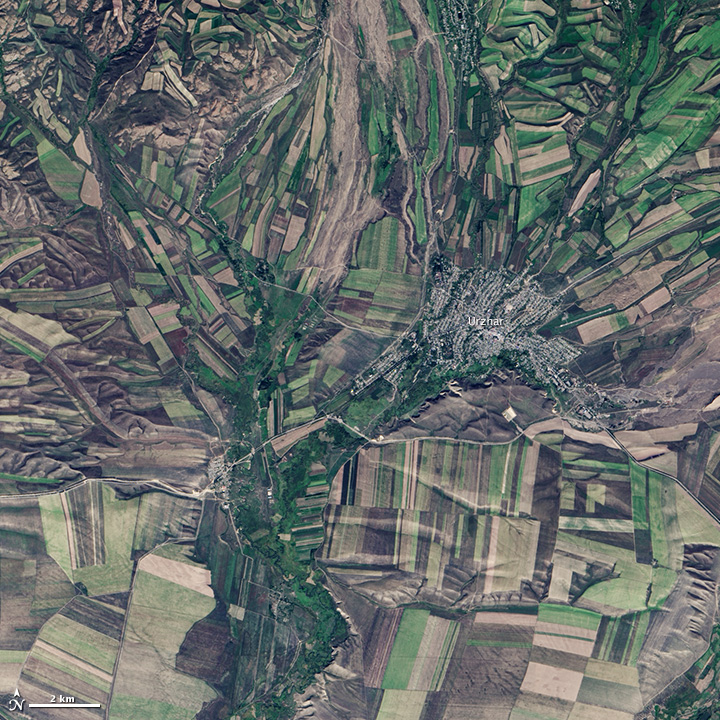
NASA: Kazakhstan - Fall Harvest in Kazakhstan - 09.27.13
Posted by Ricardo Marcenaro | Posted in NASA: Kazakhstan - Fall Harvest in Kazakhstan - 09.27.13 | Posted on 10:01

acquired September 9, 2013
download large image (6 MB, JPEG, 5000x5000)
acquired September 9, 2013
download GeoTIFF file (54 MB, TIFF)
acquired September 9, 2013
download Google Earth file (KML)
September 22, the autumnal equinox,
marks the beginning of fall in the Northern Hemisphere, but the fall
harvest begins early in the harsh continental climate of eastern
Kazakhstan. By September 9, 2013, when the Operational Land Imager (OLI) on the Landsat 8
satellite acquired this image, several fields were already harvested
and bare. Others were dark green with pasture grasses or ripening crops.
The fields fill the contours of the land, running long and narrow down
mountain valleys and spreading in large squares over the plains.
Agriculture is an important segment of the economy in Kazakhstan: the country’s dry climate is ideal for producing high quality wheat for export. However, 61 percent of the country’s agricultural land
is pasture for livestock. The area shown in this image, far eastern
Kazakhstan near the Chinese border, is a minor wheat-growing region and
may also produce sunflowers, barley, and other food crops.
An artifact of Soviet-era collective farms, most of the farms in
Kazakhstan are large, covering more than 5,000 hectares (12,500 acres).
Some of the larger fields in the image reflect the big business side of
agriculture. However, family farms and small agriculture businesses
account for 35 percent of the country’s agricultural production, and
some of these are visible as well, particularly in the uneven hills and
mountains.
Nearly all agriculture in Kazakhstan is rain fed. Farmers in this
region have designed their fields to take advantage of rain flowing down
hills, allowing the natural shape of the land to channel water to
crops. The effect is a mosaic of green and tan with tones matching the
natural vegetation in the mountains to the north.
References
- Foreign Agricultural Service (2010, January 19) Kazakstan agricultural overview. United States Department of Agriculture. Accessed September 24, 2013.
- Foreign Agricultural Service (2013, March 16) Kazakhstan wheat production: An overview. United States Department of Agriculture.< Accessed September 24, 2013.
- Akim Tarbagatay Region Geography of the region and its brief history. Accessed September 24, 2013.
NASA Earth Observatory image by Jesse Allen using Landsat data from the U.S. Geological Survey. Caption by Holli Riebeek.
- Instrument:
- Landsat 8 - OLI
NASA: Kazakhstan - Fall Harvest in Kazakhstan - 09.27.13
Ricardo M Marcenaro - Facebook
Blogs in operation of The Solitary Dog:
Solitary Dog Sculptor:
http://byricardomarcenaro.blogspot.com
Solitary Dog Sculptor I:
http://byricardomarcenaroi.blogspot.com
Para:
comunicarse conmigo,
enviar materiales para publicar,
propuestas comerciales:
marcenaroescultor@gmail.com
For:
contact me,
submit materials for publication,
commercial proposals:
marcenaroescultor@gmail.com
My blogs are an open house to all cultures, religions and countries. Be a follower if you like it, with this action you are building a new culture of tolerance, open mind and heart for peace, love and human respect.
Thanks :)
Mis blogs son una casa abierta a todas las culturas, religiones y países. Se un seguidor si quieres, con esta acción usted está construyendo una nueva cultura de la tolerancia, la mente y el corazón abiertos para la paz, el amor y el respeto humano.
Gracias :)


Comments (0)
Publicar un comentario