USA: Indonesia - Deadly Pyroclastic Flow at Paluweh Volcano - 09.06.13
Posted by Ricardo Marcenaro | Posted in USA: Indonesia - Deadly Pyroclastic Flow at Paluweh Volcano - 09.06.13 | Posted on 15:43

acquired September 4, 2013
download large image (2 MB, JPEG, 4835x3223)
acquired September 4, 2013
download GeoTIFF file (19 MB, TIFF)

acquired August 3, 2013
download large image (1 MB, JPEG, 4835x3223)
acquired August 3, 2013
download GeoTIFF file (14 MB, TIFF)
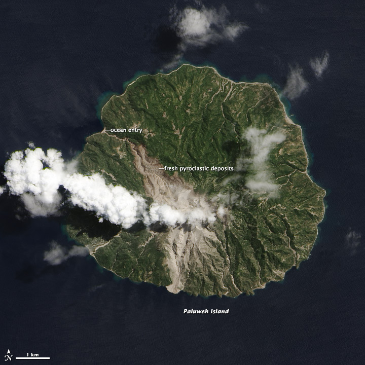
A fresh scar on the north side of Indonesia’s volcanic Paluweh
Island indicates the unpredictability of volcanic eruptions. Since the
current eruption of Paluweh (also known as Rokatenda or Palue) began in
late 2012, debris and ash had mainly flowed south from the volcano’s
summit. On August 10, 2013, a small eruption deposited material to the
north—killing five people.
A wide swath of gray that narrows to the northwest shows the probable path of the deadly pyroclastic flow.
(A pyroclastic flow is a fast-moving mix of extremely hot ash, gas,
rocks, and volcanic debris.) As it descended from the 875–meter–
(2870–foot–) summit of the volcano the flow narrowed as it was funneled
into existing stream channels. The flow entered the ocean along the
northwest coastline, extending the beach by a few meters. In the
aftermath of the eruption, the government has stepped up efforts to evacuate Paluweh.
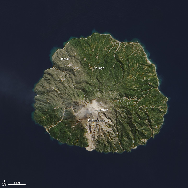
These natural-color satellite images collected by Landsat 8
show the effect of the eruption on Paluweh. The top image is from
September 4, 2013, and the lower image is from August 3, shortly before
the eruption. The summit was hidden by clouds on September 4, but
visible on August 3. Also apparent on August 3 was a light coating of
ash on vegetation on the northwest side of the island. Irregular gray
patches in the deep green forests reveal villages along the shoreline
and on the lower slopes of the volcano.
- Jakarta Globe. (August 12, 2013) Villagers Ignore Evacuation Warnings as Mount Rokatenda Erupts. Accessed September 5, 2013.
- Jakarta Globe. (August 24, 2013) Govt to Clear Out Palue Island Amid Volcanic Threat. Accessed September 5, 2013.
- Jakarta Post. (August 10, 2013) Mt. Rokatenda in NTT erupts, reportedly killing five. Accessed September 5, 2013.
- Smithsonian Global Volcanism Program. Paluweh. Accessed September 5, 2013.
NASA Earth Observatory images by Jesse Allen and Robert Simmon, using Landsat 8 data from the USGS Earth Explorer.
- Instrument:
- Landsat 8 - OLI
USA: Indonesia - Deadly Pyroclastic Flow at Paluweh Volcano - 09.06.13
Ricardo M Marcenaro - Facebook
Blogs in operation of The Solitary Dog:
Solitary Dog Sculptor:
http://byricardomarcenaro.blogspot.com
Solitary Dog Sculptor I:
http://byricardomarcenaroi.blogspot.com
Para:
comunicarse conmigo,
enviar materiales para publicar,
propuestas comerciales:
marcenaroescultor@gmail.com
For:
contact me,
submit materials for publication,
commercial proposals:
marcenaroescultor@gmail.com
My blogs are an open house to all cultures, religions and countries. Be a follower if you like it, with this action you are building a new culture of tolerance, open mind and heart for peace, love and human respect.
Thanks :)
Mis blogs son una casa abierta a todas las culturas, religiones y países. Se un seguidor si quieres, con esta acción usted está construyendo una nueva cultura de la tolerancia, la mente y el corazón abiertos para la paz, el amor y el respeto humano.
Gracias :)


Comments (0)
Publicar un comentario