NASA: Antartica - Antartida - Flying Over Vostok Station - 12.27.13
Posted by Ricardo Marcenaro | Posted in NASA: Antartica - Antartida - Flying Over Vostok Station - 12.27.13 | Posted on 17:47

acquired November 27, 2013
download large image (5 MB, JPEG, 5616x3744)
If you were flying inland over
Antarctica’s Princess Elizabeth Land and peering out of the window of
your plane, you wouldn’t find much variety to the scenery. There are no
forests, no meandering rivers, no soaring mountains. What you would see
instead is a seemingly endless, flat expanse of wind-blown snow and
ice—the surface of one of the thick ice sheets that shrouds most of Antarctica.
But if you happened to be passing over the south geomagnetic pole,
you would see a cluster of buildings and equipment scattered on the ice
surface. This is Vostok Station, one of the most remote research
stations in the world. Established by the former Soviet Union in 1957
and now operated by Russia, the station is located about 1,300
kilometers (800 miles) from the geographic South Pole
on top of approximately 3,700 meters (2.3 miles) of ice. During the
summer research season, Vostok Station supports about 30 people.
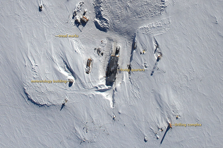
An airborne camera, the Digital Mapping System (DMS), captured this image (top) of the station as NASA’s P-3 was flying over on November 27, 2013. The DMS camera, which was mounted on the bottom of the airplane, was at nadir
when the image was taken, meaning it was pointing directly down at the
surface. A number of features were visible from the plane’s 1,500-feet
(460-meter) cruising altitude, including drilling equipment,
communication towers, and the station’s meteorology building. The plane
was surveying as part of Operation IceBridge, a multi-year mission to monitor conditions in Antarctica and the Arctic until a new ice-monitoring satellite, ICESat-2, launches in 2016.
While the primary objective of Operation IceBridge is to collect information about the thickness of ice sheets with laser altimeters and radar sensors,
the DMS acquires high-resolution natural color photographs that
scientists can use to monitor conditions at the ice surface. On most
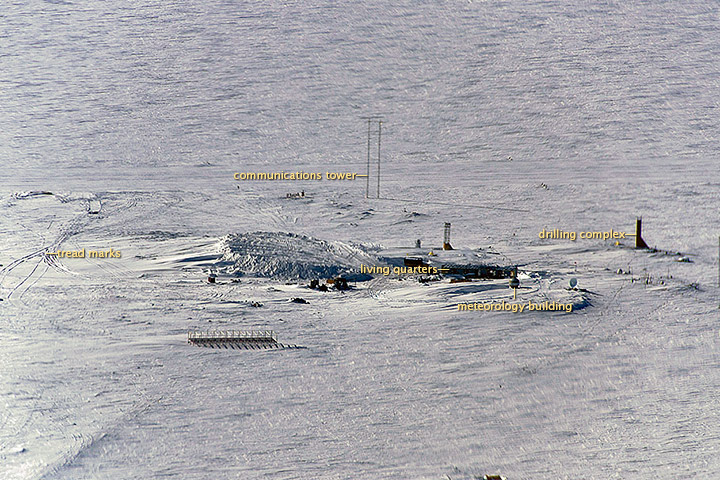
flights, IceBridge project scientist Michael Studinger brings his own digital camera as well. Studinger took the bottom photograph as the plane approached Vostok Station.
Before taking over the leadership of Operation IceBridge, Studinger was involved in a project to study Lake Vostok, a massive subglacial lake
deep beneath the station. The lake, discovered in 1996 with a radar on
the European ERS-1 satellite, is about the size of Lake Ontario and has
been covered by ice for up to 25 million years. A Russian team succeeded in drilling all the way down to the lake in 2012 as part of an effort to study microbes living in the lake.
References and Further Reading
- New York Times (2012, February 8) Russian Scientists Bore Into Ancient Antarctic Lake. Accessed December 19, 2013.
- Columbia University Subglacial Lake Vostok. Accessed December 19, 2013.
- Nature (2012, February 14) Russians celebrate Vostok victory. Accessed December 19, 2013.
- Wissard Whillans Ice Stream Subglacial Access Research Drilling Project (2012, December 21) Polar Science is Cool. Accessed December 19, 2013.
- South Pole Station Lake Vostok Drilling Project. Accessed December 19, 2013.
- Russian Antarctic Expedition Station Vostok. Accessed December 19, 2013.
NASA Earth Observatory image, using data from the Digital Mapping System (DMS) acquired during an Operation IceBridge
flight. Oblique photograph courtesy of Michael Studinger, NASA Goddard
Space Flight Center. Caption by Adam Voiland.
- Instrument:
- Aircraft Sensors - DMS
NASA: Antartica - Antartida - Flying Over Vostok Station - 12.27.13
Ricardo M Marcenaro - Facebook
Blogs in operation of The Solitary Dog:
Solitary Dog Sculptor:
byricardomarcenaro.blogspot.com
Solitary Dog Sculptor I:
byricardomarcenaroi.blogspot.com/
Para:
comunicarse conmigo
comunicarse conmigo
marcenaroescultor@gmail.com
For:
contact me
For:
contact me
marcenaroescultor@gmail.com
My blogs are an open house to all cultures, religions and countries. Be a follower if you like it, with this action you are building a new culture of tolerance, open mind and heart for peace, love and human respect. Thanks :)
Mis blogs son una casa abierta a todas las culturas, religiones y países. Se un seguidor si quieres, con esta acción usted está construyendo una nueva cultura de la tolerancia, la mente y el corazón abiertos para la paz, el amor y el respeto humano. Gracias:)
(::)


Comments (0)
Publicar un comentario