
NASA: It is happening now - Está sucediendo ahora - 13-06-11 - United States - Wildfires in Arizona - Intensos incendios en Arizona
Posted by Ricardo Marcenaro | Posted in NASA: It is happening now - Está sucediendo ahora - 13-06-11 - United States - Wildfires in Arizona - Intensos incendios en Arizona | Posted on 19:49
Open your mind, your heart to other cultures
Abra su mente, su corazón a otras culturas
You will be a better person
Usted será una mejor persona
RM
Abra su mente, su corazón a otras culturas
You will be a better person
Usted será una mejor persona
RM
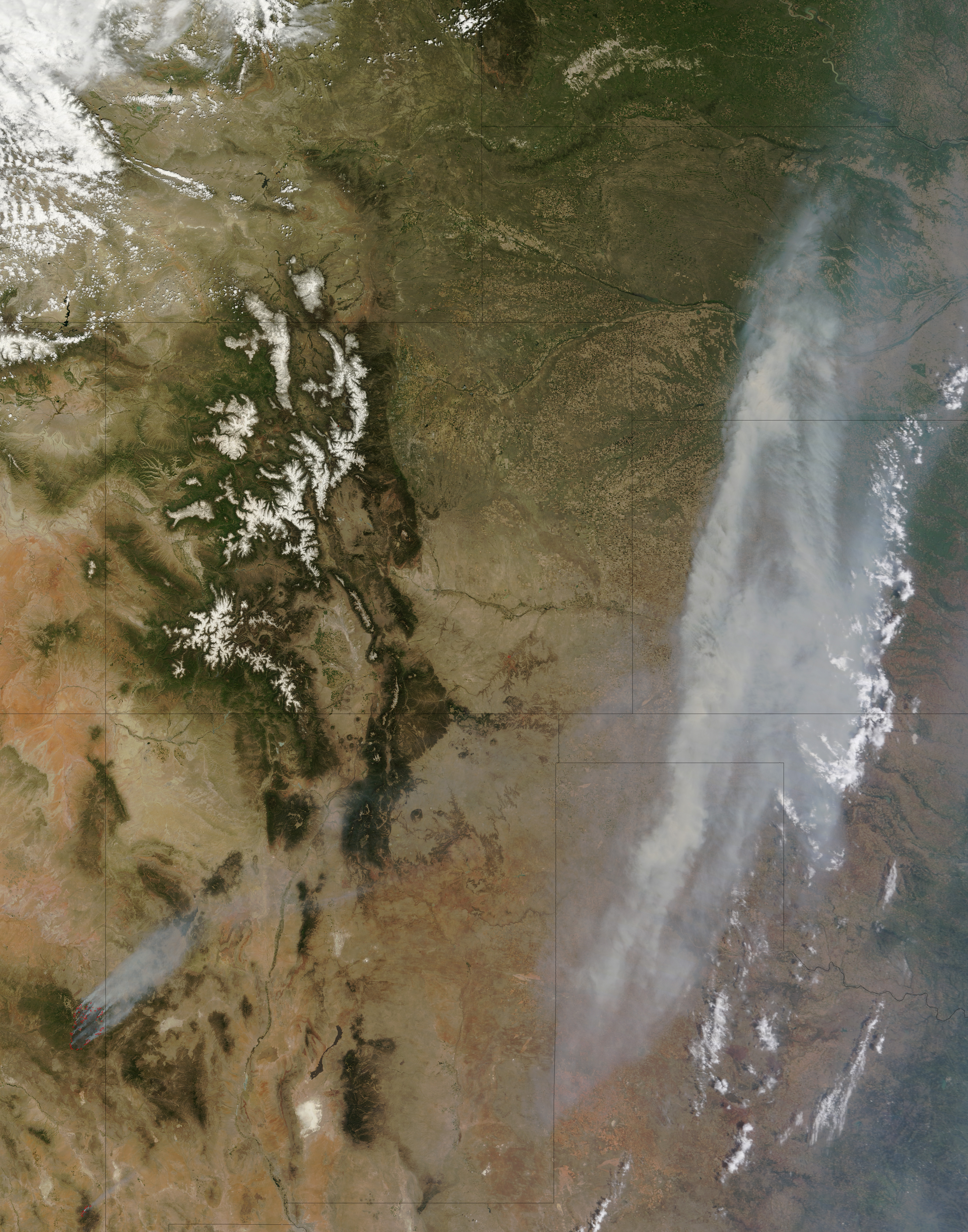
Wallow Fire Sends Smoke across Midwest
acquired June 7, 2011
High winds and low humidity fueled extreme fire behavior as the Wallow Fire continued to consume acres of forested land in the mountains of eastern Arizona on June 7, 2011. By the end of the day, the fire had burned 311,481 acres (487 square miles), up 77,959 acres (122 square miles) from the previous day. As the fire raged, smoke poured across the United States, clouding skies over the Midwest.
At 11:05 a.m. Arizona time, when the Moderate Resolution Imaging Spectroradiometer (MODIS) on the Terra satellite acquired this image, a dense band of smoke was visible from Texas to Nebraska. Winds had blown the smoke eastward from New Mexico, Colorado, and Wyoming, where it hovered on June 5.
The thick smoke in this image was only part of the smoky haze plaguing the continental United States in early June. According to the U.S. Air Quality “Smog Blog,” smoke from fires in Arizona and New Mexico extended through Kansas and into to the Great Lakes region, affecting air quality for large areas east of the Rocky Mountains.
The Wallow Fire started on May 29, 2011. As of June 7, 2011, the fire had damaged one structure, destroyed 10 others, and threatened 343 more. As sheriffs expanded evacuation orders, fire-control crews undertook controlled burns to establish line of protection around the fire. At that time, however, the fire remained completely uncontained.
-
References
- InciWeb. (2011, June 7). Wallow Fire. Accessed June 8, 2011.
- U.S. Air Quality. (2011, June 7). Smoke from Arizona and New Mexico fires. Accessed June 8, 2011.
NASA image courtesy Jeff Schmaltz, MODIS Rapid Response Team at NASA GSFC. Caption by Holli Riebeek and Michon Scott.
- Instrument: Terra - MODIS
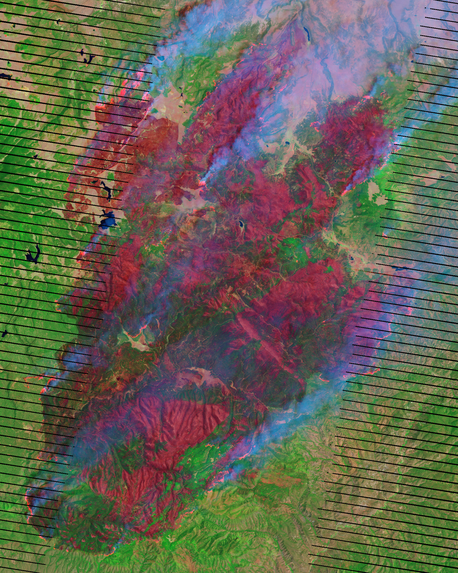
Wallow Fire, Arizona
acquired June 7, 2011
An oasis of green in the desert southwest, the Apache National Forest covers the mountains due east of Phoenix and spills across the border with New Mexico. In late May and early June 2011, the island of forest became fuel for one of the largest fires in Arizona history, the Wallow Fire. This image, taken by the Landsat-7 satellite on June 7, shows the northern edge of the fire.
The image was made with infrared light. Bright red spots are actively burning areas, and darker red areas are freshly burned ground. Unburned forest and grassland is green, while sparsely planted earth or bare ground is pale pink. In many places, the fire has burned right to the edge of the forest. The image shows that the fire is intense: It has thoroughly burned the forest leaving few ribbons or patches of green in its wake.
As of June 8, the Wallow Fire had burned 389,000 acres (608 square miles) and was completely uncontained. Several communities have been evacuated, and the Apache National Forest is closed to the public. The Wallow Fire started on May 29, 2011.
References
- InciWeb. (2008, June 8). Wallow. Accessed June 9, 2011.
- U.S. Forest Service. (2011, June 9). Apache and Sitgreaves National Forests. United States Department of Agriculture. Accessed June 9, 2011.
NASA Earth Observatory image created by Jesse Allen and Robert Simmon, using Landsat data provided by the United States Geological Survey. Caption by Holli Riebeek.
- Instrument:
- Landsat 7 - ETM+
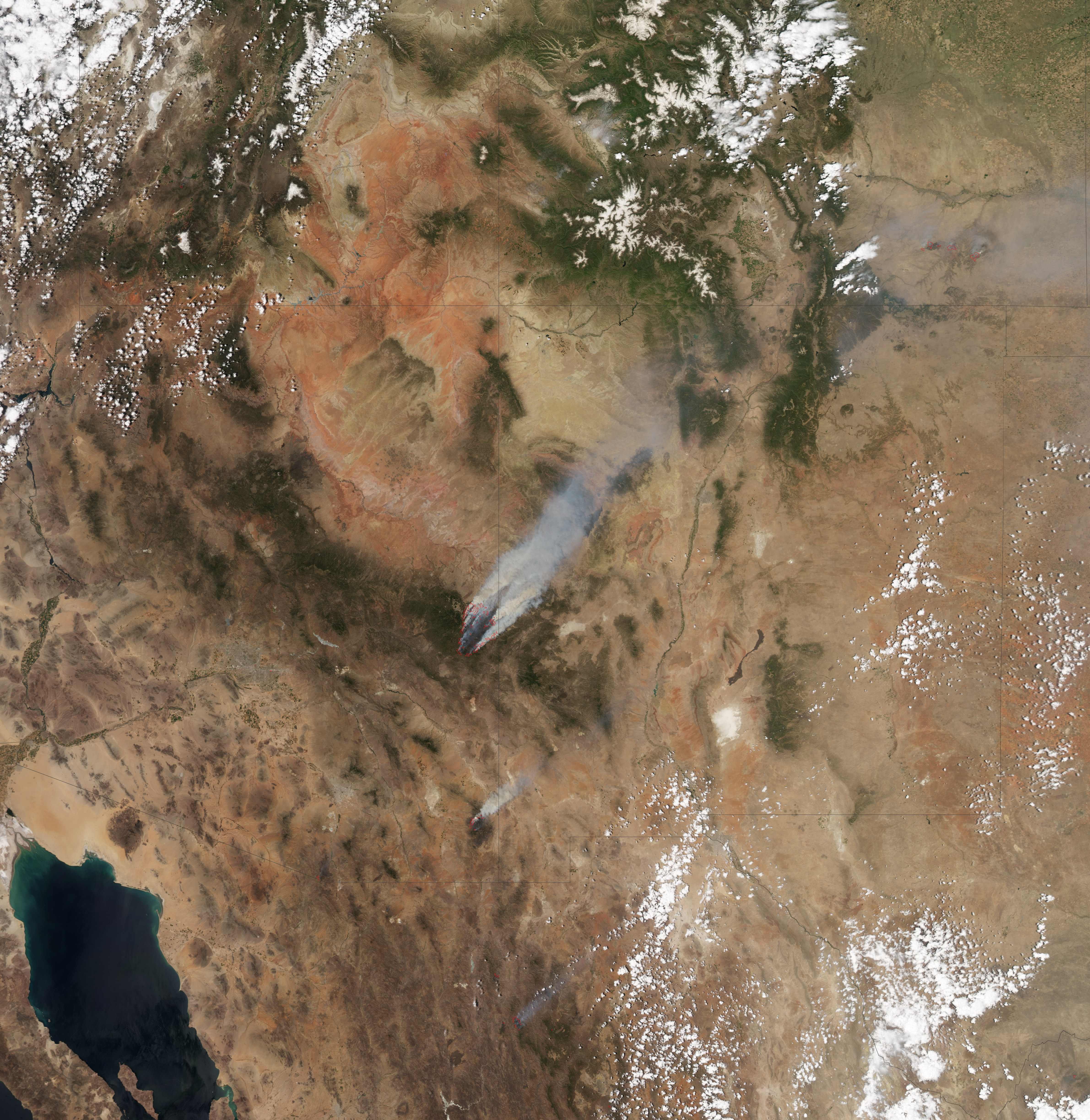 acquired June 8, 2011
 The Wallow Fire has become the second largest fire in Arizona history. By early afternoon on June 8, 2011, the fire had consumed 389,000 acres (608 square miles), largely in the Apache National Forest, and was not at all contained. This image, taken by the Moderate Resolution Imaging Spectroradiometer (MODIS) on the Aqua satellite, shows the fire at 1:25 p.m. local time.
The actively burning fire front (outlined in red) surrounds a vast area of charred land. High winds propelled the fire, igniting spot fires as much as three miles ahead of the fire front on June 8, said the Arizona Emergency Information Network. Dense plumes of smoke billow from the fire and stream northeast in the strong winds. The smoke has been affecting air quality through much of the United States.
The Wallow Fire started because of human activity on May 29. It has forced evacuations from several eastern Arizona communities including Sunrise, Greer, Blue River, Alpine, Nutrioso, Eager, and Springerville. As of June 8, the fire has threatened 588 structures and destroyed 11.
References
- Arizona Emergency Information Network. (2011, June 8). Firefighters reinforce fire line on Wallow Fire. Accessed June 8, 2011.
- InciWeb. (2011, June 8). Wallow. Accessed June 8, 2011.
NASA Earth Observatory image created by Jesse Allen, using data provided courtesy of the University of Wisconsin’s Space Science and Engineering Center MODIS Direct Broadcast system. Caption by Holli Riebeek.
- Instrument:
- Aqua - MODIS
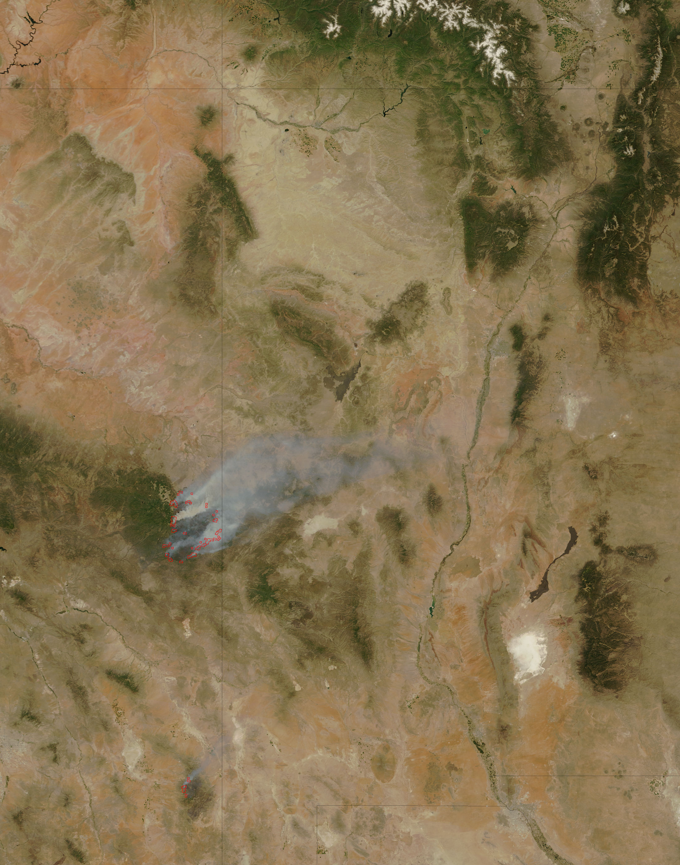
acquired June 9, 2011
By the end of the day on June 9, 2011, Arizona’s massive Wallow Fire had reached 386,690 acres (609 square miles or 157,701 hectares) and had burned 29 and threatened 5,242 homes. Most of the homes destroyed were in Greer. Approximately 3,012 people are working to contain the fire, which is now just five percent contained. Calmer winds on June 10 should help firefighters make more progress on containing the fire, said InciWeb.
The Moderate Resolution Imaging Spectroradiometer (MODIS) on the Terra satellite acquired this image of the Wallow Fire on June 9 at 10:55 a.m. local time. Active fire areas are outlined in red. Smoke rises from the most intensely burning areas, but overall, the fire is producing less smoke than in previous days.
The Moderate Resolution Imaging Spectroradiometer (MODIS) on the Terra satellite acquired this image of the Wallow Fire on June 9 at 10:55 a.m. local time. Active fire areas are outlined in red. Smoke rises from the most intensely burning areas, but overall, the fire is producing less smoke than in previous days.
Reference
- InciWeb. (2011, June 10). Wallow Fire. Accessed June 10, 2011.
NASA image courtesy Jeff Schmaltz, MODIS Rapid Response Team at NASA GSFC. Caption by Holli Riebeek.
- Instrument:
- Terra - MODIS
acquired June 7, 2011
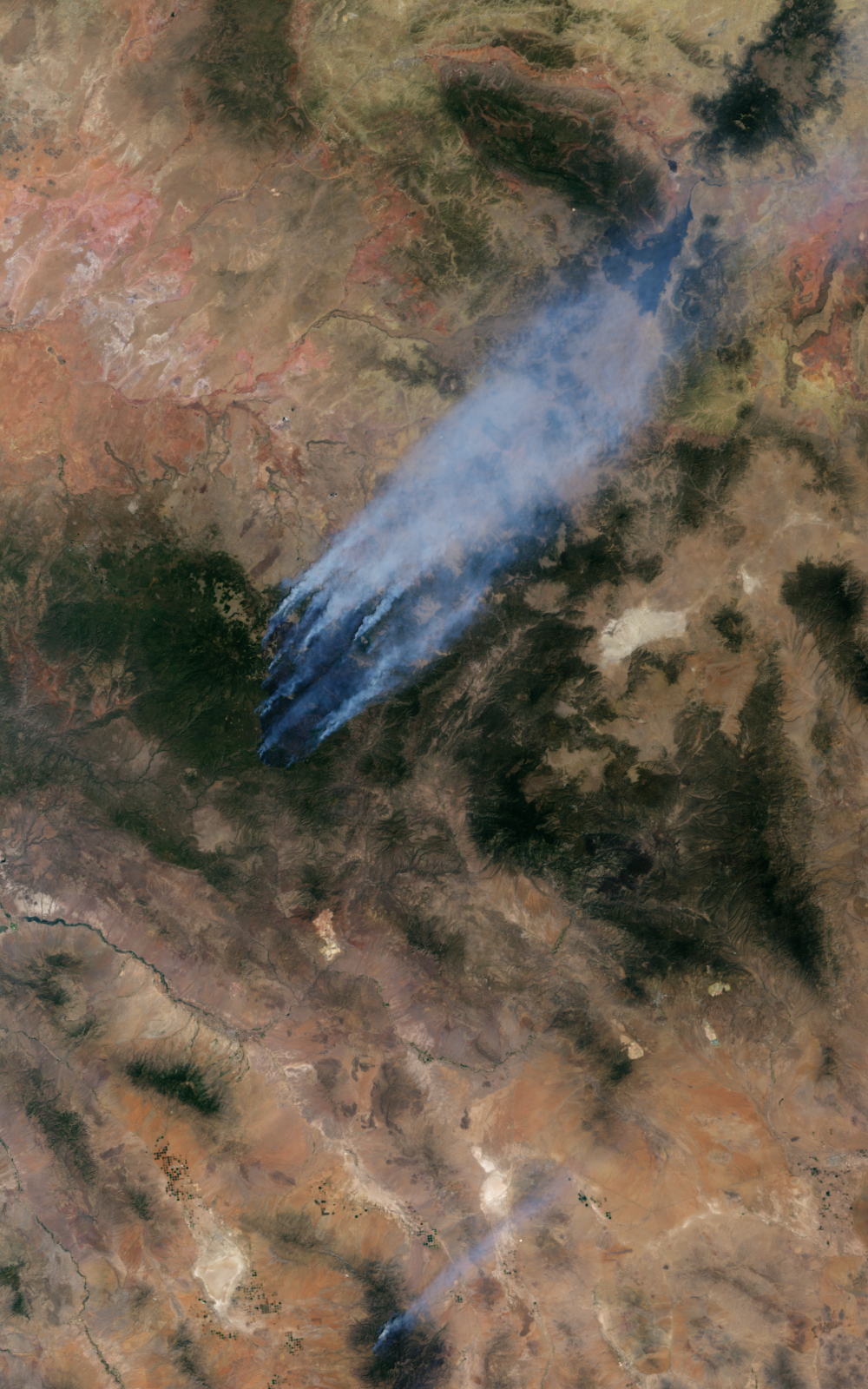
This image and accompanying animation from the Multi-angle Imaging SpectroRadiometer (MISR) instrument on the Terra spacecraft show the Wallow Fire currently burning in Arizona. The data were acquired mid-morning (local time) on June 7, 2011.
As of June 8, the large Wallow fire in the White Mountains has burned more than 389,000 acres (more than 608 square miles, or 1,574 square kilometers) and is currently the second largest fire in Arizona history. More than 2,000 people are working to contain the fire, which is being driven by high winds and low humidity.
The Wallow Fire is in the center of the MISR image. Nearly 10 distinct bluish-colored smoke plumes can be seen blowing toward the upper right (northeast). The green pine forests of the White Mountains stand out against the lighter desert background. In this image, the windblown smoke is seen extending into New Mexico; smoke from this fire has been carried over the Great Plains as far as Iowa.
The animation shows sequential views from MISR’s nine cameras, which observe the scene over a period of seven minutes from different view angles. Smoke can be seen rising from local hot spots due to the time lapse between the different images. The images at the beginning and end of the sequence are from MISR’s more oblique cameras and observe a longer path through the atmosphere, making the smoke appear thicker and easier to resolve against the bright desert background. The areas with no data (shown in black and present at the oblique angles) are locations where the variable terrain has obscured lower elevation ground.
NASA Earth Observatory image created by Jesse Allen, using data provided by the NASA/GSFC/JPL, MISR Team. Caption adapted from the Jet Propulsion Laboratory Photojournal.
- Instrument:
- Terra - MISR
NASA: It is happening now - Está sucediendo ahora - 13-06-11 - United States - Wildfires in Arizona - Intensos incendios en Arizona
You have an alphabetical guide in the foot of the page in the blog: solitary dog sculptor
In the blog: Solitary Dog Sculptor I, the alphabetical guide is on the right side of the page
Thanks
Usted tiene una guía alfabética al pie de la página en el blog: solitary dog sculptor
En el blog: Solitary Dog Sculptor I, la guia alfabética está en el costado derecho de la página
Gracias
Ricardo M Marcenaro - Facebook
Blogs in operation of The Solitary Dog:
solitary dog sculptor:
http://byricardomarcenaro.blogspot.com
Solitary Dog Sculptor I:
http://byricardomarcenaroi.blogspot.com
Para:
comunicarse conmigo,
enviar materiales para publicar,
propuestas comerciales:
marcenaroescultor@gmail.com
For:
contact me,
submit materials for publication,
commercial proposals:
marcenaroescultor@gmail.com
Diario La Nación
Argentina
Cuenta Comentarista en el Foro:
Capiscum
My blogs are an open house to all cultures, religions and countries. Be a follower if you like it, with this action you are building a new culture of tolerance, open mind and heart for peace, love and human respect.
Thanks :)
Mis blogs son una casa abierta a todas las culturas, religiones y países. Se un seguidor si quieres, con esta acción usted está construyendo una nueva cultura de la tolerancia, la mente y el corazón abiertos para la paz, el amor y el respeto humano.
Gracias :)

Comments (0)
Publicar un comentario