
NASA: United States - Waters Spread Across Floodway above Morgan City - Distribucion de aguas en cauce de alivio encima de Morgan City.
Posted by Ricardo Marcenaro | Posted in NASA: United States - Waters Spread Across Floodway above Morgan City - Distribucion de aguas en cauce de alivio encima de Morgan City. | Posted on 17:08
Open your mind, your heart to other cultures
Abra su mente, su corazón a otras culturas
You will be a better person
Usted será una mejor persona
RM
Abra su mente, su corazón a otras culturas
You will be a better person
Usted será una mejor persona
RM
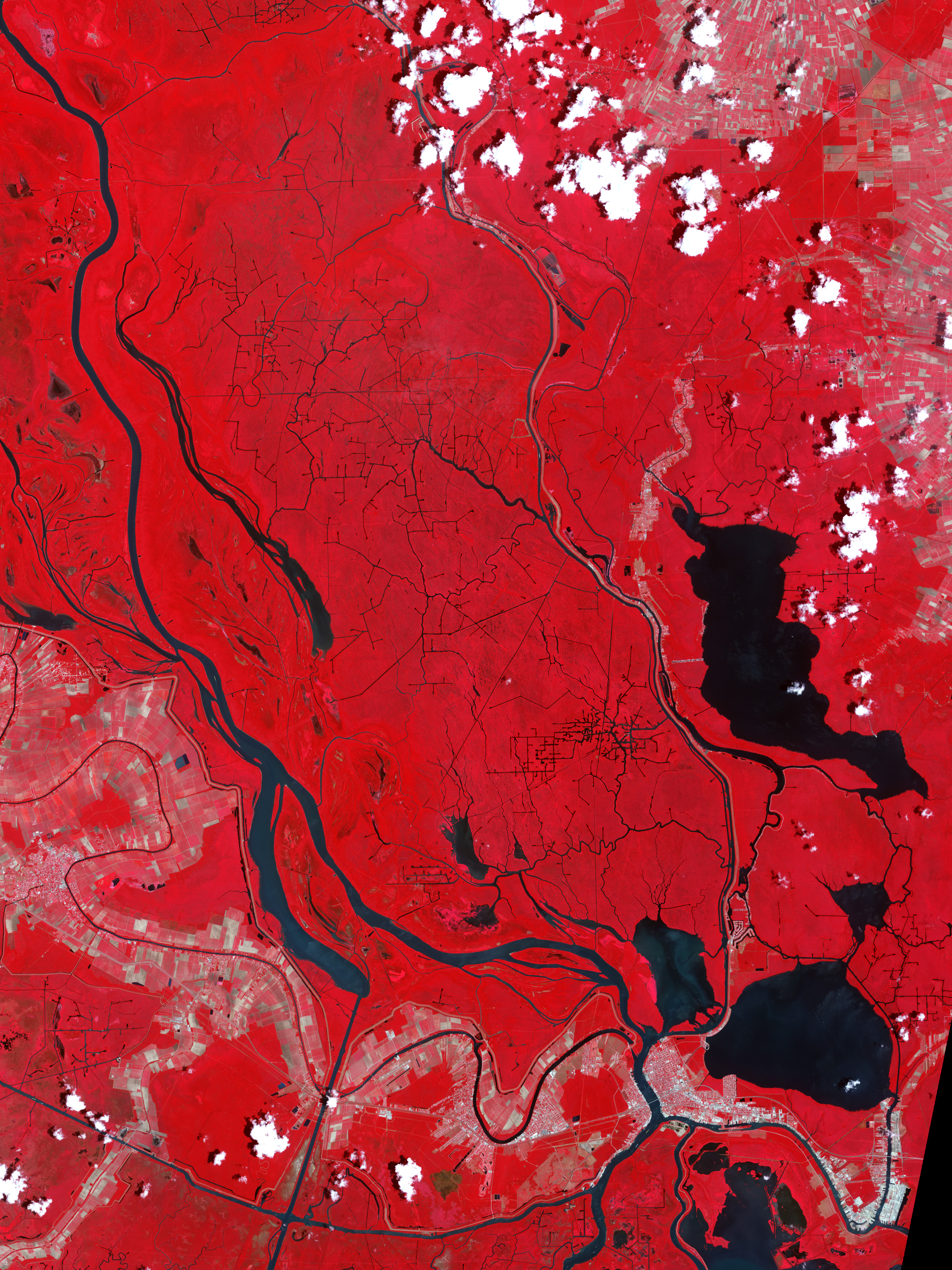
acquired May 27, 2011
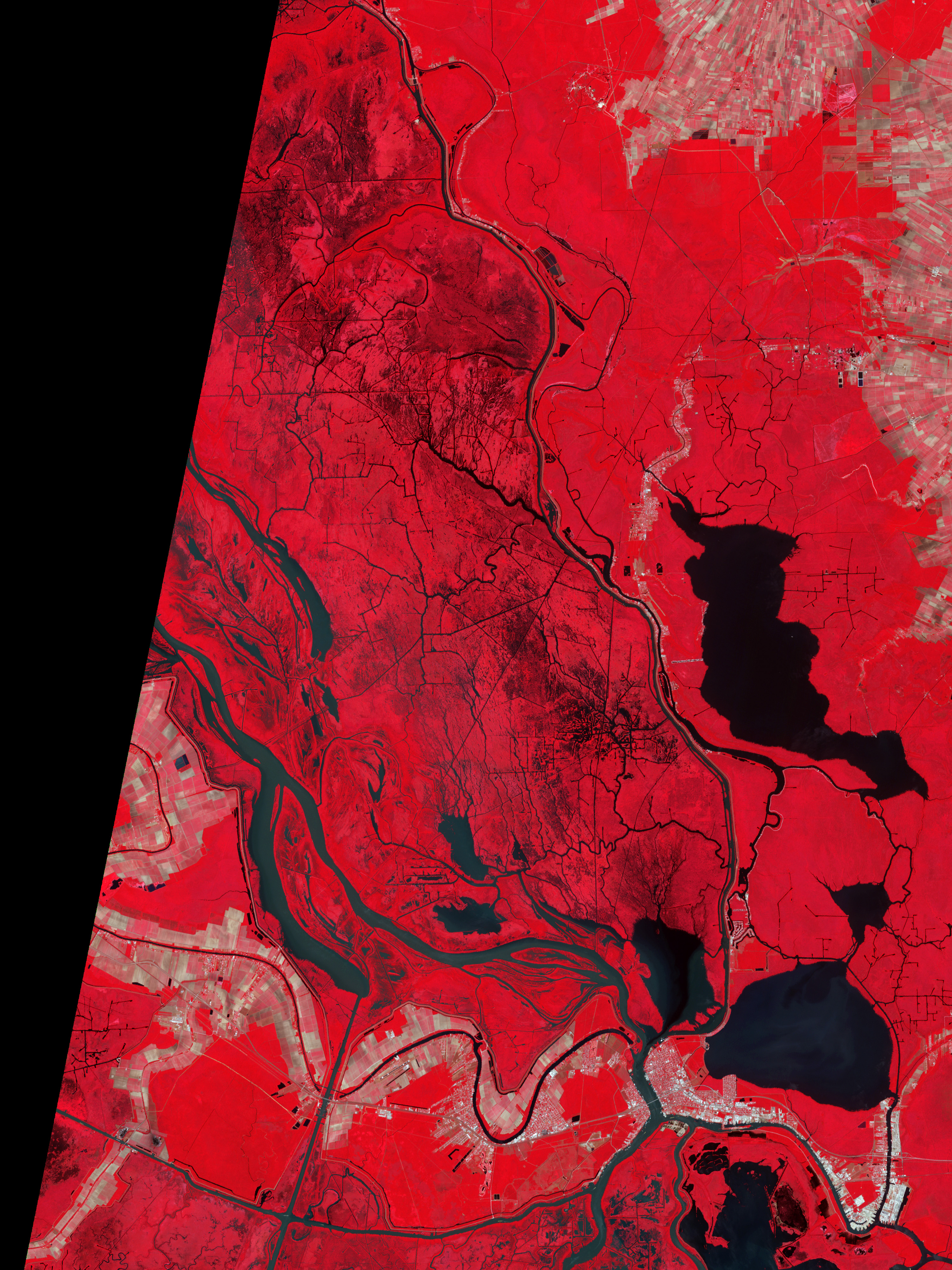
acquired June 30, 2006
Two weeks after the U.S. Army Corps of Engineers opened the flood control structure known as the Morganza Spillway, the Advanced Spaceborne Thermal Emission and Reflection Radiometer (ASTER) on NASA’s Terra satellite captured this false-color image of the downstream area above Morgan City, Louisiana.
The top image was acquired on May 27, 2011, and the lower image shows the area around the end of spring flood season in June 2006. The false–color images combine infrared, red, and green wavelengths to help distinguish between water and land. Clear water is blue, and sediment-laden water is a dull blue-gray. Vegetation is red; the brighter the red, the more robust the vegetation.
Compared to a normal year, many of the rivers and channels appear somewhat wider and fuller in May 2011, but not significantly so. Much of the Mississippi and Atchafalaya Rivers are bounded by levees and other river control structures that keep the water flowing within the banks.
However, the black and green-gray shading amidst the red-colored vegetation north and west of Morgan City, Louisiana, are tell-tale signs of flood waters amidst the trees and brush of the bayou swamps.
As of June 7, 2011, seven bays on the Morganza spillway remained open, down from 17 bays on May 18. The estimated flow was 70,000 cubic feet (1,980 cubic meters) per second flowing out of the Mississippi River and into the floodway. The river has crested at all of the major cities along its banks, and the high point of the water flow appears to be past. Yet there is still plenty of water washing across the Louisiana landscape toward the Gulf of Mexico.
-
References
- U.S. Army Corps of Engineers (n.d.). Current information for 2011 flood fight. Accessed June 4, 2011.
- USA Today (2011, May 26) Corps closing floodgates on Morganza Spillway. Accessed June 4, 2011.
NASA Earth Observatory image created by Robert Simmon and Jesse Allen, using data provided courtesy of NASA/GSFC/METI/ERSDAC/JAROS, and U.S./Japan ASTER Science Team. Caption by Mike Carlowicz.
- Instrument:
- Terra - ASTER
NASA: United States - Waters Spread Across Floodway above Morgan City - Distribucion de aguas en cauce de alivio encima de Morgan City.
You have an alphabetical guide in the foot of the page in the blog: solitary dog sculptor
In the blog: Solitary Dog Sculptor I, the alphabetical guide is on the right side of the page
Thanks
Usted tiene una guía alfabética al pie de la página en el blog: solitary dog sculptor
En el blog: Solitary Dog Sculptor I, la guia alfabética está en el costado derecho de la página
Gracias
Ricardo M Marcenaro - Facebook
Blogs in operation of The Solitary Dog:
solitary dog sculptor:
http://byricardomarcenaro.blogspot.com
Solitary Dog Sculptor I:
http://byricardomarcenaroi.blogspot.com
Para:
comunicarse conmigo,
enviar materiales para publicar,
propuestas comerciales:
marcenaroescultor@gmail.com
For:
contact me,
submit materials for publication,
commercial proposals:
marcenaroescultor@gmail.com
Diario La Nación
Argentina
Cuenta Comentarista en el Foro:
Capiscum
My blogs are an open house to all cultures, religions and countries. Be a follower if you like it, with this action you are building a new culture of tolerance, open mind and heart for peace, love and human respect.
Thanks :)
Mis blogs son una casa abierta a todas las culturas, religiones y países. Se un seguidor si quieres, con esta acción usted está construyendo una nueva cultura de la tolerancia, la mente y el corazón abiertos para la paz, el amor y el respeto humano.
Gracias :)

Comments (0)
Publicar un comentario