
NASA: United States - Massachusetts - Tornado Track near Sturbridge - Marca del camino del tornado cerca de Sturbridge
Posted by Ricardo Marcenaro | Posted in NASA: United States - Massachusetts - Tornado Track near Sturbridge - Marca del camino del tornado cerca de Sturbridge | Posted on 13:33
Open your mind, your heart to other cultures
Abra su mente, su corazón a otras culturas
You will be a better person
Usted será una mejor persona
RM
Abra su mente, su corazón a otras culturas
You will be a better person
Usted será una mejor persona
RM
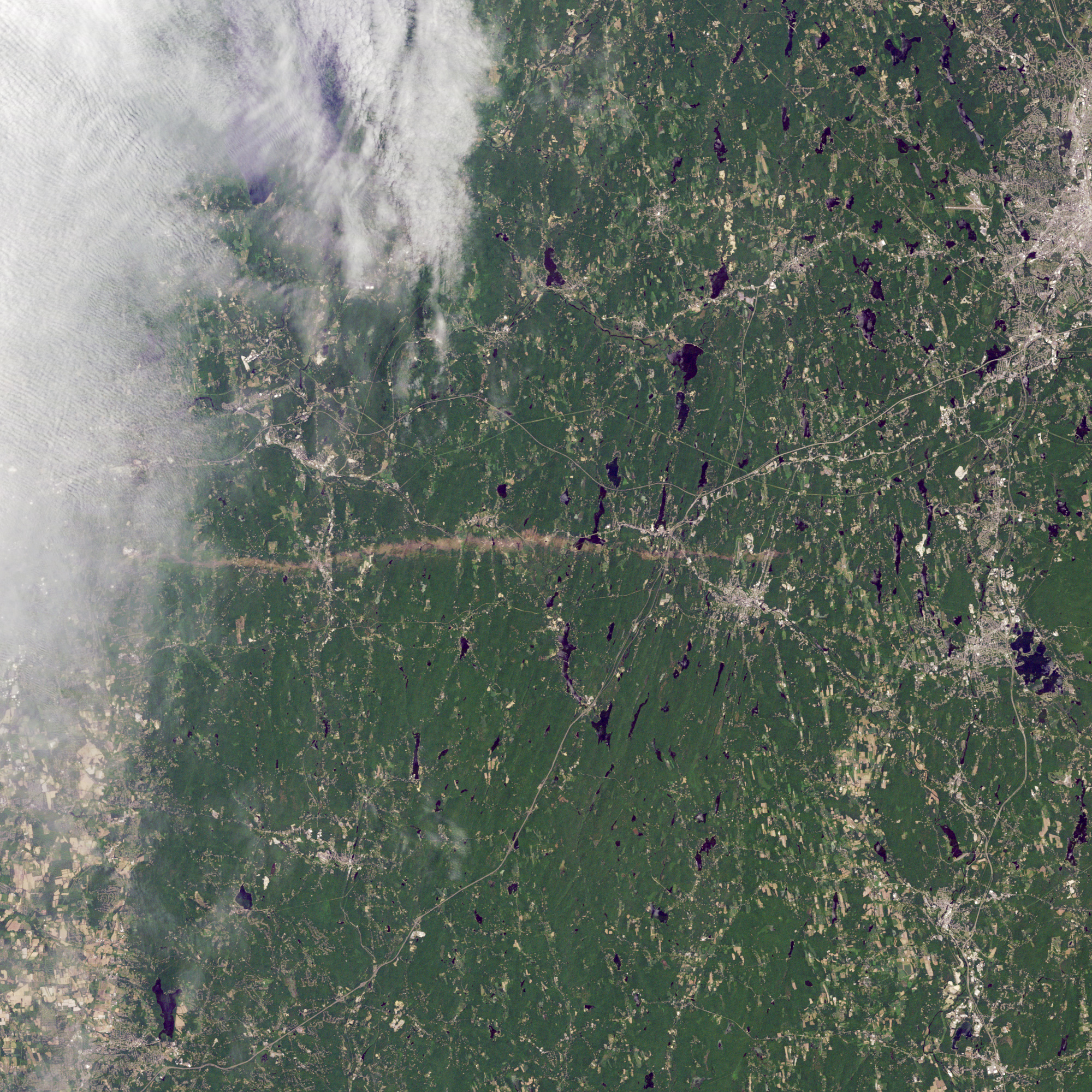
acquired June 5, 2011
On June 1, 2011, a supercell thunderstorm developed over western Massachusetts. The storm produced an EF3 tornado that cut a 39-mile (63-kilometer) track of destruction across southwest and south-central Massachusetts. Not only did the tornado remain on the ground for many miles, but it also widened to roughly 0.5 miles (0.8 kilometers) in Brimfield State Forest.
The Thematic Mapper on the Landsat 5 satellite captured this natural-color image on June 5, 2011, showing part of the tornado track including damage in Sturbridge. According to The Boston Globe, Massachusetts state police reported a tornado on the ground and cars overturned near Interstate 84 in Sturbridge at 5:22 p.m. on June 1.
When the tornado first touched down in the Munger Hill section of Westfield, Massachusetts, damage was mostly limited to trees, the National Weather Service reported. The tornado quickly intensified, however, as it traveled to West Springfield. The Boston Globe reported two deaths in West Springfield, one in Springfield, and another in Brimfield. The number of people injured was unknown the day after the storm, but 33 people were known to have been injured in Springfield alone.
Massachusetts Governor Deval Patrick declared a state of emergency and ordered National Guard troops to assist with cleanup efforts. Tornadoes killed at least four residents, while reducing homes, schools, and churches to rubble.
Deadly tornadoes are unusual, but not unheard of, in Massachusetts. In 1953, one of the single deadliest tornadoes in U.S. history struck Worcester, killing 94 people.
-
References
- Boston Globe. (2011, June 2). Tornado damage graphic. Accessed June 6, 2011.
- Boston Globe. (2011, June 2). Tornadoes kill four, emergency is declared. Accessed June 6, 2011.
- National Weather Service, Taunton, Massachusetts. (2011, June 3). Public Information Statement. Accessed June 6, 2011.
NASA Earth Observatory image created by Jesse Allen, using Landsat data provided by Julia Barsi of the Landsat Project Science Office. Landsat is jointly managed by the U.S. Geological Survey and NASA. Caption by Michon Scott.
- Instrument:
- Landsat 5 - TM
NASA: United States - Massachusetts - Tornado Track near Sturbridge - Marca del camino del tornado cerca de Sturbridge
You have an alphabetical guide in the foot of the page in the blog: solitary dog sculptor
In the blog: Solitary Dog Sculptor I, the alphabetical guide is on the right side of the page
Thanks
Usted tiene una guía alfabética al pie de la página en el blog: solitary dog sculptor
En el blog: Solitary Dog Sculptor I, la guia alfabética está en el costado derecho de la página
Gracias
Ricardo M Marcenaro - Facebook
Blogs in operation of The Solitary Dog:
solitary dog sculptor:
http://byricardomarcenaro.blogspot.com
Solitary Dog Sculptor I:
http://byricardomarcenaroi.blogspot.com
Para:
comunicarse conmigo,
enviar materiales para publicar,
propuestas comerciales:
marcenaroescultor@gmail.com
For:
contact me,
submit materials for publication,
commercial proposals:
marcenaroescultor@gmail.com
Diario La Nación
Argentina
Cuenta Comentarista en el Foro:
Capiscum
My blogs are an open house to all cultures, religions and countries. Be a follower if you like it, with this action you are building a new culture of tolerance, open mind and heart for peace, love and human respect.
Thanks :)
Mis blogs son una casa abierta a todas las culturas, religiones y países. Se un seguidor si quieres, con esta acción usted está construyendo una nueva cultura de la tolerancia, la mente y el corazón abiertos para la paz, el amor y el respeto humano.
Gracias :)

Comments (0)
Publicar un comentario