
NASA: United States - Wallow Fire Burn Scar. Arizona - Las Conchas Fire - New Mexico - Canada - Wildfires in Western Canada
Posted by Ricardo Marcenaro | Posted in NASA: United States - Wallow Fire Burn Scar. Arizona - Las Conchas Fire - New Mexico - Canada - Wildfires in Western Canada | Posted on 20:48
Open your mind, your heart to other cultures
Abra su mente, su corazón a otras culturas
You will be a better person
Usted será una mejor persona
RM
Abra su mente, su corazón a otras culturas
You will be a better person
Usted será una mejor persona
RM

acquired June 21, 2011
Even as firefighters finish containing the biggest fire in Arizona history, work is already underway to restore the forest. The first step in planning a recovery is to assess how badly the forest was burned, and satellite images like this one play a significant role.
Arizona’s Wallow Fire was first reported on May 29, 2011. Fueled by extremely dry conditions and helped by strong winds, the fire had burned 538,049 acres of forest in the White Mountains of eastern Arizona by June 28. But as it burned, the Wallow Fire was not all-consuming. This image shows areas that were completely burned, side-by-side with areas that were moderately or lightly burned or not touched at all.
The Advanced Spaceborne Thermal Emission and Reflection Radiometer (ASTER) on the Terra satellite acquired this image on June 21, 2011. Plant-covered land is red in the false-color image, which includes both visible and infrared light. Patches of unburned forest are bright red, in subtle contrast with slightly darker areas where flecks of black indicate some burning. The charcoal-colored areas burned severely. The severe burns are fringed by slightly lighter shades of gray where the burn was moderate. The fire was still burning when ASTER took this image, and the pale blue haze along the lower border is smoke.
Satellite images such as this one are necessary in assessing damage from extremely large or remote wildfires. Responders identify the most severely affected areas where the land may need to be stabilized to prevent further damage. Responders also use these assessments to create a recovery plan.
The recovery plan for the Wallow Fire is in development, but officials are already warning of the potential for dangerous floods and landslides. As this image shows, sections of the Wallow Fire burned all of the stabilizing plants on steep mountain slopes. The charred soil does not absorb water, and as a result, even moderate rain may trigger floods and landslides.
References
- InciWeb. (2011, June 27). Wallow. Accessed June 28, 2011.
- Parsons, A., Robichaud, P.R., Lewis, S.A., Napper, C., and Clark, J.T. (2010, October). Field guide for mapping post-fire soil burn severity. (pdf) United States Department of Agriculture Forest Service. Accessed June 27, 2011.
- Remote Sensing Applications Center. Burned area emergency response (BAER) imagery support. United States Department of Agriculture Forest Service. Accessed June 27, 2011.
- United States Department of Agriculture Forest Service. Burned area emergency reponse, BAER. Accessed June 27, 2011.
NASA Earth Observatory image by Jesse Allen using data from the NASA/GSFC/METI/ERSDAC/JAROS, and U.S./Japan ASTER Science Team. Caption by Holli Riebeek.
- Instrument:
- Terra - ASTER
acquired June 27, 2011
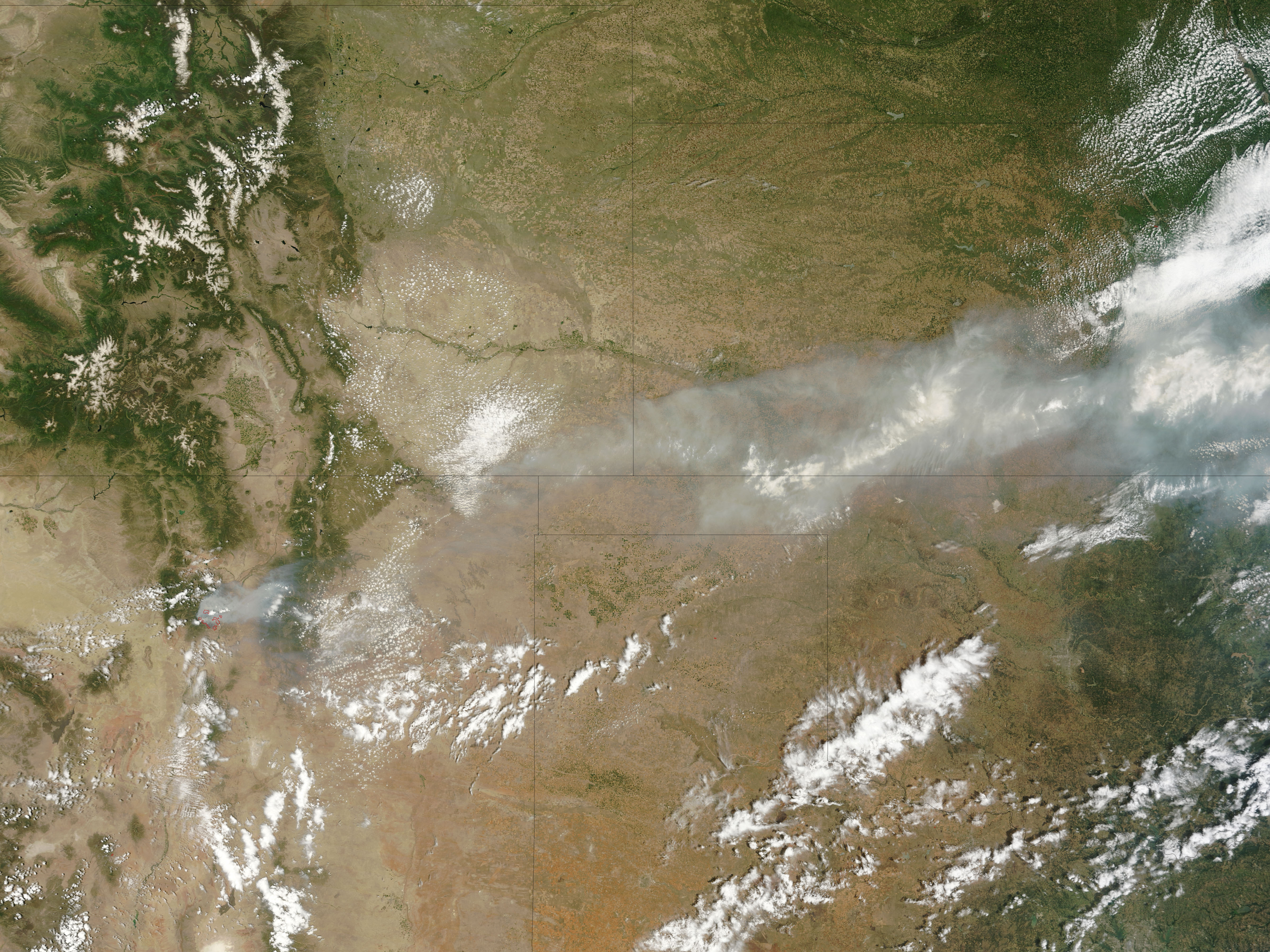
The Las Conchas Fire, burning southwest of Los Alamos, New Mexico, continued to spread on June 27, 2011. The Moderate Resolution Imaging Spectroradiometer (MODIS) on the Terra satellite acquired this image at 11:40 a.m. local time.
Active fire locations are outlined in red. The fire bathed Los Alamos and the Rio Grande Valley to the east with thick smoke. The large image, which includes a wider area, shows the dense smoke extending northeast over Texas and Kansas.
By the end of the day on June 27, the Las Conchas Fire had burned 43,597 acres (17,643 hectares) since starting around 1:00 p.m. on June 26. The fire burned within a mile of the Los Alamos National Laboratory, but had not entered the lab. The lab and nearby Bandelier National Monument are closed, and the city of Los Alamos, Cochiti Mesa, and Las Conchas have been evacuated.
Reference
- InciWeb. (2011, June 28). Las Conchas Wildfire. Accessed June 28, 2011.
NASA image courtesy Jeff Schmaltz, MODIS Rapid Response Team at NASA GSFC. Caption by Holli Riebeek.
- Instrument:
- Terra - MODIS
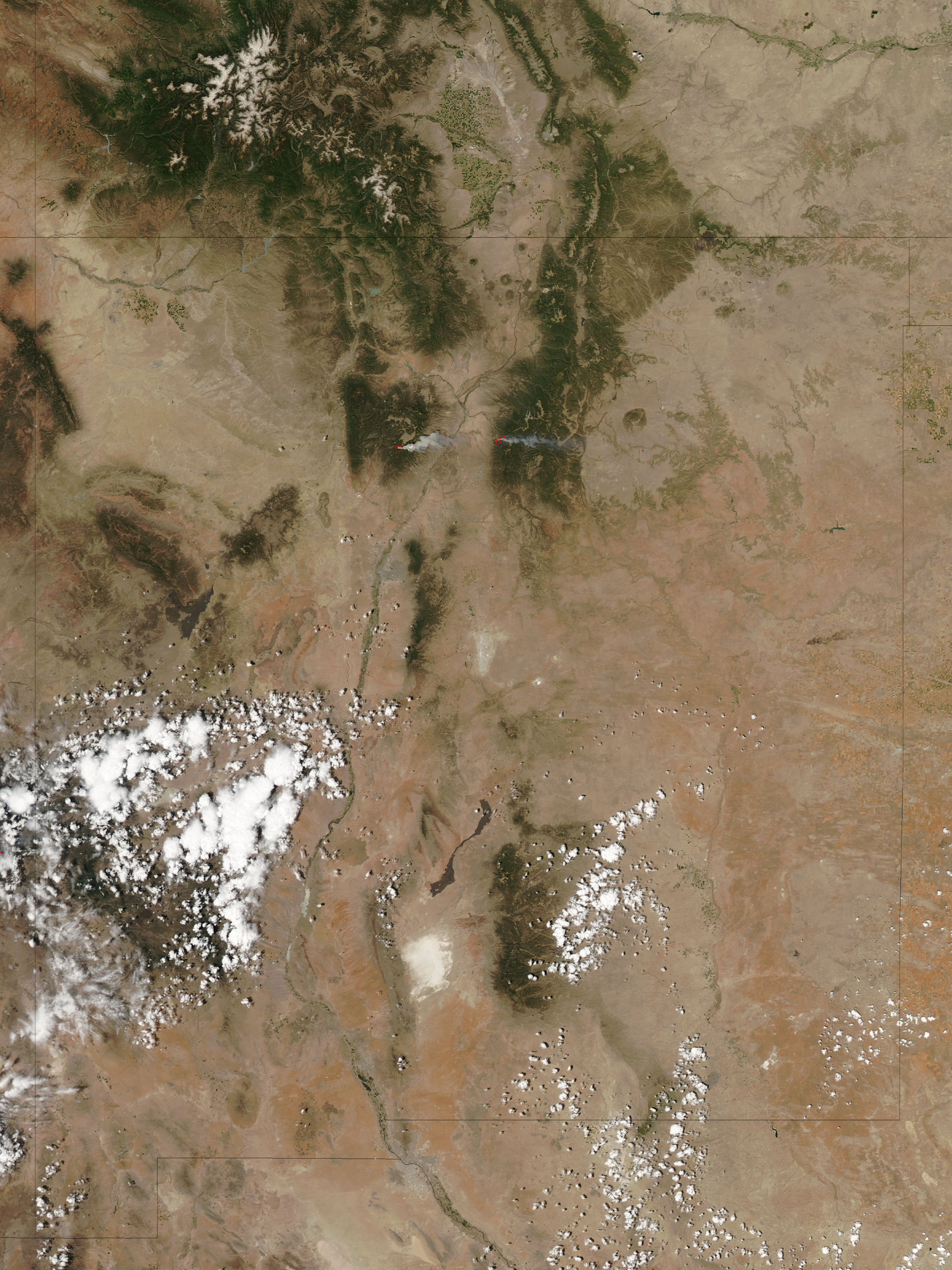
High temperatures, low humidity, and strong winds allowed the Los Conchas Fire, burning near Los Alamos, New Mexico, to grow very quickly on June 26, 2011. The Moderate Resolution Imaging Spectroradiometer (MODIS) on NASA’s Aqua satellite captured this image about an hour and a half after the fire started. Within that short time, the fire had already become intense enough to send a towering plume of smoke east over Los Alamos, about 12 miles (19 kilometers) to the northeast. The active fire region is outlined in red.
By the morning of June 27, the fire had burned 43,597 acres (17,643 hectares or 176 square km), bringing down power and phone lines. The fire forced about 100 people out of their homes in the communities of Cochiti Mesa and Los Conchas and closed Bandelier National Monument and Los Alamos National Laboratory. As of about 10 a.m. local time, the fire was about a mile from the southwest boundary of the lab.
The image also shows the smaller Pacheco Fire burning in the Santa Fe National Forest east of the Rio Grande. The Pacheco Fire started on June 18 and has burned 9,334 acres (3,777 hectares or 38 square km).
References
- InciWeb. (2011, June 27). Las Conchas Fire. Accessed June 27, 2011.
- InciWeb. (2011, June 27). Pacheco Fire. Accessed June 27, 2011.
- Los Alamos Monitor. (2011, June 27). Las Conchas wildfire at 43,000+ acres; County under voluntary evacuation; Lab closed today. Accessed June 27, 2011.
- Remote Sensing Applications Center. (2011, June 27). Fire detection map, Southwest (AZ, NM, Southwestern TX). United States Department of Agriculture Forest Service. Accessed June 27, 2011.
NASA image courtesy the MODIS Rapid Response Team at NASA GSFC. Caption by Holli Riebeek.
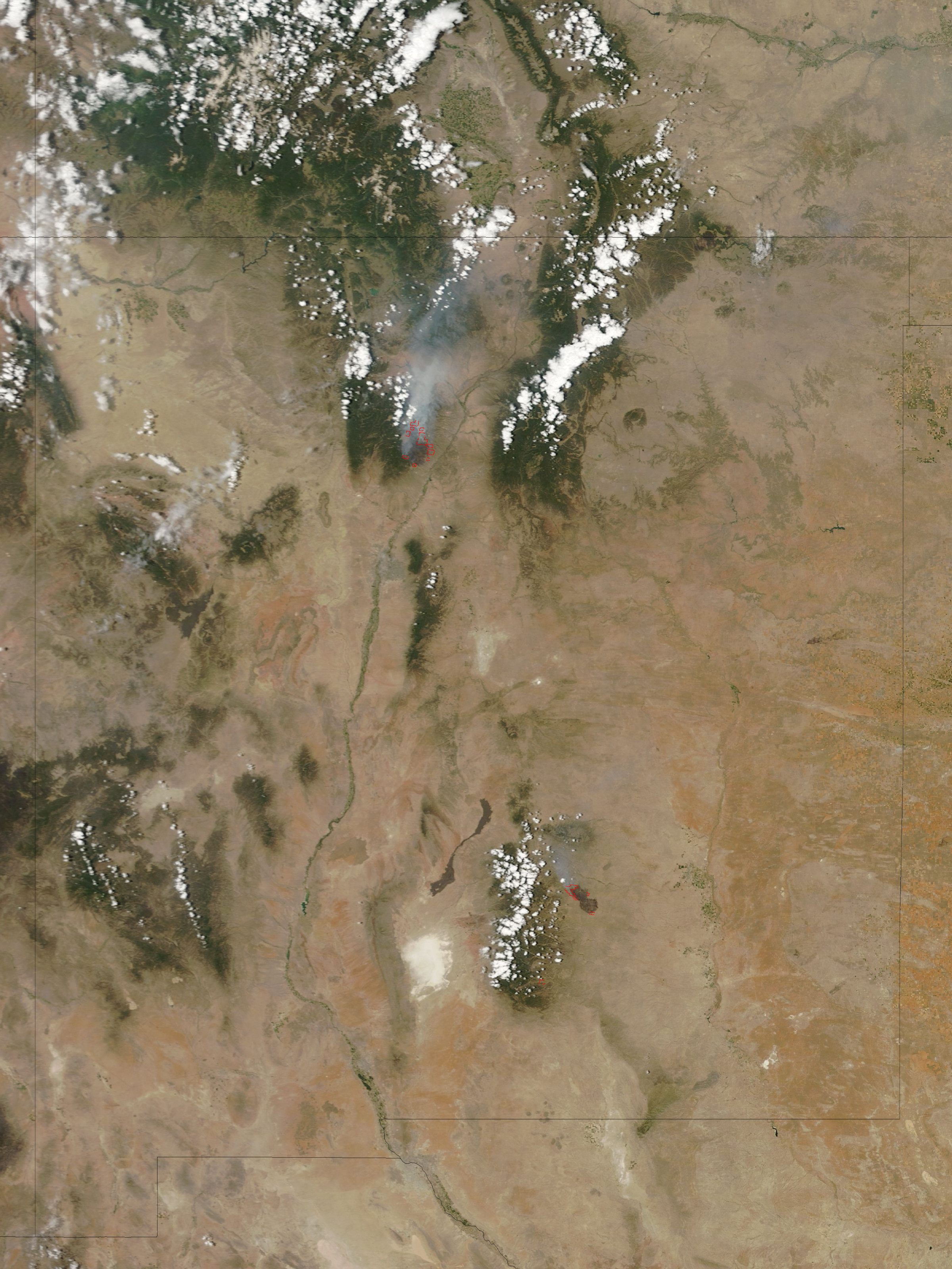
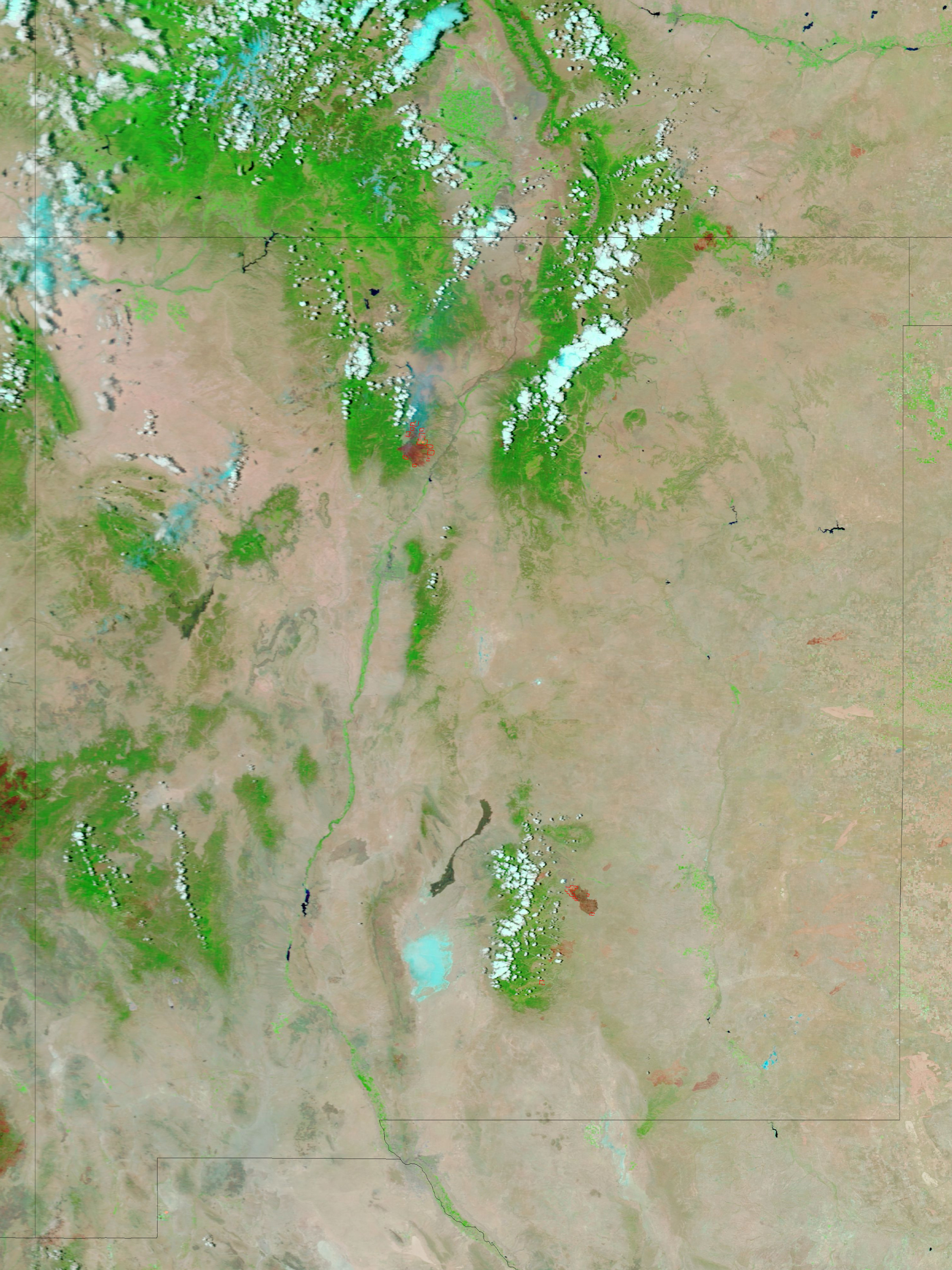
Burning along the western edge of Los Alamos National Laboratory, the Las Conchas Fire in New Mexico reached 92,735 acres on June 30, 2011. The fire has destroyed 13 homes and forced the evacuation of the city of Los Alamos. South of the city, the national lab has been closed all week, though preventative burns have kept the fire off lab property. The Las Conchas Fire started on June 26 and is 3 percent contained.
These two images, taken by the Moderate Resolution Imaging Spectroradiometer (MODIS) on the Terra satellite, show the fire on June 29. Active fire areas are outlined in red. The top image shows a natural color view of the fire. The lower image combines visible and infrared light to show the area burned throughout the week. In the infrared light, the smoke is a faint blue haze that allows a view of the ground below. The hot fire glows orange, and the newly burned land is dark red. Similar images of New Mexico are available twice daily from the MODIS Rapid Response System.
References
- InciWeb. (2011, June 30). Las Conchas. Accessed June 30, 2011.
- InciWeb. (2011, June 29). Los Alamos Fire Chief: Preventative burns were successful. Accessed June 30, 2011.
NASA images courtesy the MODIS Rapid Response Team at NASA GSFC. Caption by Holli Riebeek.
- Instrument:
- Terra - MODIS
Wildfires in Western Canada
acquired June 26, 2011
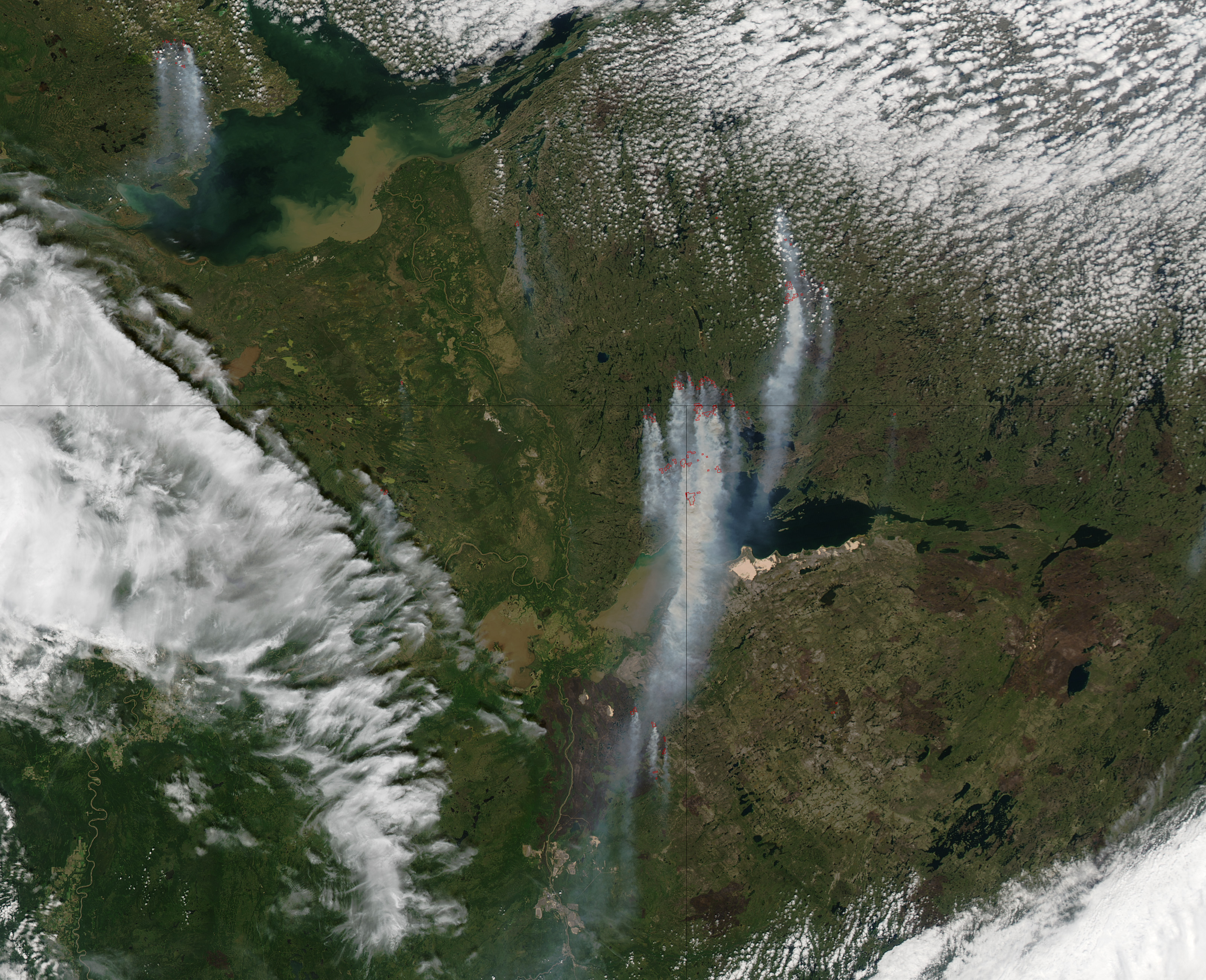
Hot, dry weather contributed to the growth of several wildfires near the borders of Alberta, Saskatchewan, and the Northwest Territories of Canada in late June 2011. This image, taken by the Moderate Resolution Imaging Spectroradiometer (MODIS) on the Aqua satellite on June 26, shows thick smoke streaming south from a cluster of wildfires, outlined in red.
In the south, a dark brown burn-scar defines the area burned in the Richardson Fire that started on May 15. On June 27, local officials reported that the Richardson Fire burned a staggering 613,360 hectares (1,515,646 acres or 2,368 square miles). The fire is part of the Bitumont Complex, which may include some of the fires burning along the east side of the burn scar.
So far in 2011, Canada has experienced fewer fires than average, but the fires have burned 277 percent more land than average. More than half of the 1,179,669 hectares burned in 2011 to date were consumed in the Richardson Fire.
References
- Canadian Forest Service. (2011, June 22). National wildland fire situation report. Accessed June 28, 2011.
- CBC News. (2011, June 24). Fort Smith prepares for wildfire risk. Accessed June 28, 2011.
- Fort McMurray. (2011, June 27). Nine active wildfires in Waterways District; all being held or under control. Accessed June 28, 2011.
- Gennings, K. (2011, June 22). Fires burn as dry weather continues. Slave River Journal. (registration required). Accessed June 28, 2011.
NASA image courtesy Jeff Schmaltz, MODIS Rapid Response Team at NASA GSFC. Caption by Holli Riebeek.
- Instrument:
- Aqua - MODIS
NASA: United States - Wallow Fire Burn Scar. Arizona - Las Conchas Fire - New Mexico - Canada - Wildfires in Western Canada
You have an alphabetical guide in the foot of the page in the blog: solitary dog sculptor
In the blog: Solitary Dog Sculptor I, the alphabetical guide is on the right side of the page
Thanks
Usted tiene una guía alfabética al pie de la página en el blog: solitary dog sculptor
En el blog: Solitary Dog Sculptor I, la guia alfabética está en el costado derecho de la página
Gracias
Ricardo M Marcenaro - Facebook
Blogs in operation of The Solitary Dog:
solitary dog sculptor:
http://byricardomarcenaro.blogspot.com
Solitary Dog Sculptor I:
http://byricardomarcenaroi.blogspot.com
Para:
comunicarse conmigo,
enviar materiales para publicar,
propuestas comerciales:
marcenaroescultor@gmail.com
For:
contact me,
submit materials for publication,
commercial proposals:
marcenaroescultor@gmail.com
Diario La Nación
Argentina
Cuenta Comentarista en el Foro:
Capiscum
My blogs are an open house to all cultures, religions and countries. Be a follower if you like it, with this action you are building a new culture of tolerance, open mind and heart for peace, love and human respect.
Thanks :)
Mis blogs son una casa abierta a todas las culturas, religiones y países. Se un seguidor si quieres, con esta acción usted está construyendo una nueva cultura de la tolerancia, la mente y el corazón abiertos para la paz, el amor y el respeto humano.
Gracias :)

Comments (0)
Publicar un comentario