NASA: Ship Tracks and Vortices over the North Pacific Ocean - 12.05.13
Posted by Ricardo Marcenaro | Posted in NASA: Ship Tracks and Vortices over the North Pacific Ocean - 12.05.13 | Posted on 21:02

acquired April 20, 2013
download large image (6 MB, JPEG, 6000x6000)
acquired April 20, 2013
download GeoTIFF file (45 MB, TIFF)
When ships and islands interact, it’s
usually because ships are docking or departing with passengers or
cargo. But ships and islands interacted in a different way in the
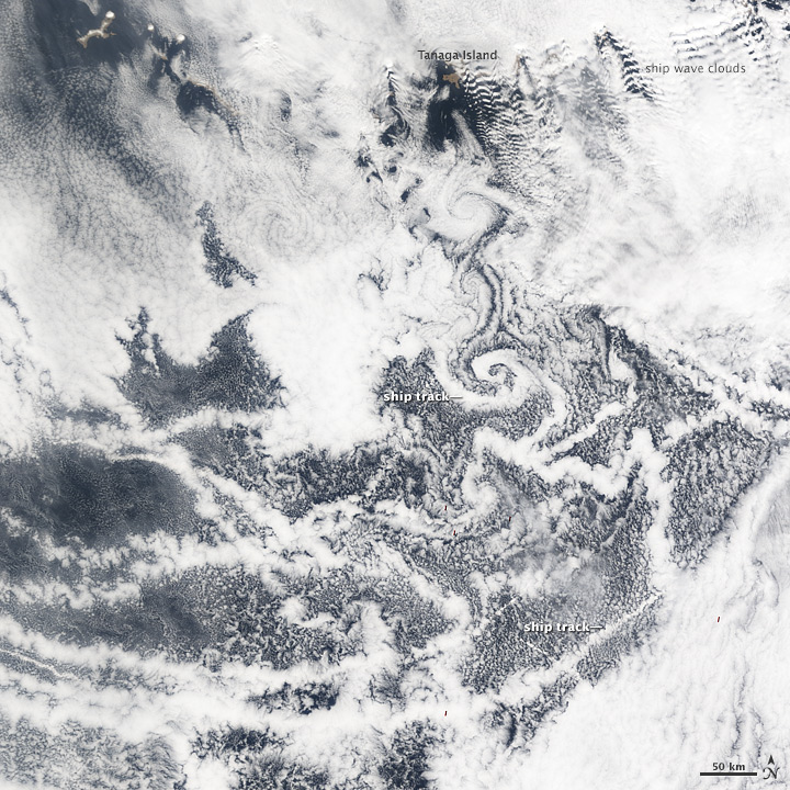
northern Pacific Ocean in April 2013. The result looked like marbled paper. Clouds that formed around ship exhaust (ship tracks) mingled with cloud vortices that had formed off of the Aleutian Islands.
The Moderate Resolution Imaging Spectroradiometer (MODIS) on NASA’s Terra satellite captured this natural-color image on April 20. The ship-track clouds and cloud vortices occurred inside an area of relatively clear skies inside a larger expanse of marine clouds. The long, thin ship tracks stretched roughly east-west, and appeared slightly brighter than the surrounding marine clouds.
The relative brightness of ship tracks results from the way they are formed. Cloud droplets form as tiny spheres of water around airborne particles, or aerosols. The particles may be natural—such as desert dust or sea salt—or artificial—such as the particles from ship exhaust. Compared to natural aerosols, ship exhaust particles are smaller and more concentrated within a given area, seeding smaller, more numerous cloud droplets. The spheres of water in clouds all reflect sunlight, but some reflect light better than others. Compared to a big sphere, a small sphere has a greater surface-to-volume ratio, and the greater surface area makes for a better reflector. So water droplets in ship-track clouds reflect more light than cloud droplets seeded by natural particles.
Although the ship tracks over the Pacific Ocean in late April 2013 mostly ran east-west, some took on swirling shapes, perhaps caught up in the cloud vortices off the Aleutian Islands. When a moving air mass encounters an obstacle such as a volcanic island, the wind flow is disrupted. Downstream from the obstacle, von Karman vortices sometimes form. These double-row vortices alternate the direction and rotation of air. Clouds make the vortices visible, and the results are beautiful paisley patterns. A line of vortices can be seen stretching southward from Tanaga Island.
Yet another distinct cloud formation is visible in the image above: ship wave clouds. Just as vortices can result from an obstruction to air flow, air that rises and falls can create atmospheric wave patterns. Clouds near the wave tops are brighter than clouds near the wave bottoms. These clouds are named for the waves formed in the wakes of boats.
Related Reading
- Ship Tracks South of Alaska
- Ship Wave Clouds over the North Sea
NASA Earth Observatory image by Jesse Allen, using data from the Land Atmosphere Near real-time Capability for EOS (LANCE). Caption by Michon Scott with information from Steve Platnick, Goddard
Space Flight Center.
- Instrument:
- Terra - MODIS
NASA: Ship Tracks and Vortices over the North Pacific Ocean - 12.05.13
Ricardo M Marcenaro - Facebook
Blogs in operation of The Solitary Dog:
Solitary Dog Sculptor:
byricardomarcenaro.blogspot.com
Solitary Dog Sculptor I:
byricardomarcenaroi.blogspot.com/
Para:
comunicarse conmigo
comunicarse conmigo
marcenaroescultor@gmail.com
For:
contact me
For:
contact me
marcenaroescultor@gmail.com
My blogs are an open house to all cultures, religions and countries. Be a follower if you like it, with this action you are building a new culture of tolerance, open mind and heart for peace, love and human respect. Thanks :)
Mis blogs son una casa abierta a todas las culturas, religiones y países. Se un seguidor si quieres, con esta acción usted está construyendo una nueva cultura de la tolerancia, la mente y el corazón abiertos para la paz, el amor y el respeto humano. Gracias:)
(::)


Comments (0)
Publicar un comentario