NASA: Canada - Sea Ice Clearing from Northwest Passage - August 2012
Posted by Ricardo Marcenaro | Posted in NASA: Canada - Sea Ice Clearing from Northwest Passage - August 2012 | Posted on 12:46

acquired August 2, 2012
download large image (8 MB, JPEG, 7452x4968)
acquired August 2, 2012
download GeoTIFF file (93 MB, TIFF)
In late July 2012, sea ice retreated
from Parry Channel in the Northwest Passage. The Canadian Ice Service
reported that ice cover in the channel began to fall below the 1981–2010
median after July 16, and the ice loss accelerated over the following
two weeks.
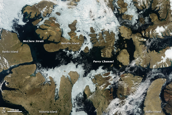
The Moderate Resolution Imaging Spectroradiometer (MODIS) on NASA’s Terra satellite captured this natural-color image of Parry Channel and McClure Strait (also known as M’Clure Strait) on August 2, 2012. Although Parry Channel was almost entirely ice free, some ice lingered between Melville and Victoria Islands. In this image, that ice varies in color from nearly white to dark gray.
For centuries, explorers and traders have sought an Arctic shipping shortcut between Europe and Asia. In the early twentieth century, Norwegian explorer Roald Amundsen managed to navigate the southern route of the Northwest Passage, although the journey took him nearly three years. Parry Channel occupies the northern or “preferred” route, which also opened in 2007. The southern route through the Northwest Passage opened in 2008.
According to reports from the Canadian Ice Service, ice appeared to retreat quickly from Parry Channel in late July and early August 2012, but the channel was probably not entirely open. In some cases, sea ice can be thin enough to escape detection by a satellite sensor, but still be thick enough to hamper navigation.
References
- Canadian Ice Service. (2012, August 6) Animated map of the last 10 days and Weekly ice coverage for the season 2012: Northwest Passage, Parry Channel. Accessed August 6, 2012.
- Princeton University Library. Of Maps and Men: In Pursuit of a Northwest Passage. Accessed August 6, 2012.
- Roach, J. (2007, September 17) Arctic melt opens Northwest Passage. Accessed August 6, 2012.
NASA Earth Observatory image by Jesse Allen, using data from the Land Atmosphere Near real-time Capability for EOS (LANCE). Caption by Michon Scott, with information from Walt Meier and Ted Scambos, National Snow and Ice Data Center.
- Instrument:
- Terra - MODIS
NASA: Canada - Sea Ice Clearing from Northwest Passage - August 2012
Ricardo M Marcenaro - Facebook
Operative blogs of The Solitary Dog:
solitary dog sculptor:
http://byricardomarcenaro.blogspot.com
Solitary Dog Sculptor I:
http://byricardomarcenaroi.blogspot.com
Para:
comunicarse conmigo,
enviar materiales para publicar,
propuestas:
marcenaroescultor@gmail.com
For:
contact me,
submit materials for publication,
proposals:
marcenaroescultor@gmail.com
Diario La Nación
Argentina
Cuenta Comentarista en el Foro:
Capiscum
My blogs are an open house to all cultures, religions and countries. Be a follower if you like it, with this action you are building a new culture of tolerance, open mind and heart for peace, love and human respect.
Thanks :)
Mis blogs son una casa abierta a todas las culturas, religiones y países. Se un seguidor si quieres, con esta acción usted está construyendo una nueva cultura de la tolerancia, la mente y el corazón abiertos para la paz, el amor y el respeto humano.
Gracias :)


Comments (0)
Publicar un comentario