NASA: Australia - An Australian “Anti-storm” - 16.06.12
Posted by Ricardo Marcenaro | Posted in NASA: Australia - An Australian “Anti-storm” - 16.06.12 | Posted on 2:14

acquired June 5, 2012
download large image (6 MB, JPEG, 8200x6800)
acquired June 5, 2012
download GeoTIFF file (89 MB, TIFF)
acquired June 5, 2012
download Google Earth file (KML)
High-pressure weather systems often
bring fair weather and relatively clear skies. In early June 2012, a
high off the coast of Tasmania did just that...and in spectacular
fashion.
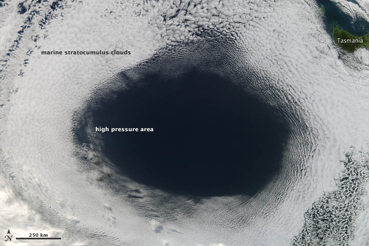
The Moderate Resolution Imaging Spectroradiometer (MODIS) on NASA’s Aqua satellite acquired this view of a hole in a cloud formation at 3:00 p.m. local time (05:00 Universal Time) on June 5, 2012. The weather system over the Great Australian Bight cut out the oval-shaped hole from a blanket of marine stratocumulus clouds.
The cloud hole, with a diameter that stretched as far as 1,000 kilometers (620 miles) across, was caused by sinking air associated with an area of high pressure near the surface. Globally, the average sea-level pressure is about 1013 millibars; at the center of this high, pressures topped 1,040 millibars.
Sea-level pressure maps published by the Australian Bureau of Meteorology on June 5 showed that the shape of the cloud hole matched the shape of the high-pressure area. However, the center of high pressure and the cloud hole didn't match precisely; the center of the high was near the western edge of the clear area, about 100 kilometers from the cloud edge.
In general, winds blow outward and away from areas of high pressure. As a result, areas of high pressure pull air downward. As the air sinks, it also warms, increasing the rate of evaporation and making it difficult for the air to sustain clouds. Areas of low pressure, by contrast, pull air upward and generate clouds and stormy weather.
While low-pressure systems often produce circular cyclonic storms and clouds, high-pressure systems (which are sometimes called anticyclones) can yield large circular areas of clear skies. “You could call it an anti-storm,” quipped NASA Langley atmospheric scientist Patrick Minnis.
According to NASA Goddard atmospheric scientists Joanna Joiner and Arlindo da Silva, weather models simulated the cloud formation quite accurately. “We checked the Global Modeling and Assimilation Office (GMAO) forecast, and it really nailed the system,” Joiner said.
Further Reading
- Earth Observatory. (2010, September 28) High Pressure Cloud Patterns, Eastern U.S.
- Earth Observatory. (2006, October 7) Marine Stratocumulus Clouds in the Pacific Northwest.
- Earth Observatory. (2003, July 11) The Highs and Lows of NAO.
- Australian Government Bureau of Meteorology. (n.d.) High and Low Pressure Systems. Accessed June 7, 2012.
NASA image courtesy Jeff Schmaltz, LANCE MODIS Rapid Response.
Caption by Adam Voiland with information from Patrick Minnis, NASA
Langley; Joanna Joiner, NASA Goddard; Steve Lang; NASA Goddard; and
Heather Hyre, NASA Goddard.
- Instrument:
- Aqua - MODIS
Ricardo M Marcenaro - Facebook
Operative blogs of The Solitary Dog:
solitary dog sculptor:
http://byricardomarcenaro.blogspot.com
Solitary Dog Sculptor I:
http://byricardomarcenaroi.blogspot.com
Para:
comunicarse conmigo,
enviar materiales para publicar,
propuestas:
marcenaroescultor@gmail.com
For:
contact me,
submit materials for publication,
proposals:
marcenaroescultor@gmail.com
Diario La Nación
Argentina
Cuenta Comentarista en el Foro:
Capiscum
My blogs are an open house to all cultures, religions and countries. Be a follower if you like it, with this action you are building a new culture of tolerance, open mind and heart for peace, love and human respect.
Thanks :)
Mis blogs son una casa abierta a todas las culturas, religiones y países. Se un seguidor si quieres, con esta acción usted está construyendo una nueva cultura de la tolerancia, la mente y el corazón abiertos para la paz, el amor y el respeto humano.
Gracias :)


Comments (0)
Publicar un comentario