
NASA: MABEL flies her last science flight for Spring 2011 - Helping scientists
Posted by Ricardo Marcenaro | Posted in NASA: MABEL flies her last science flight for Spring 2011 - Helping scientists | Posted on 20:16
Open your mind, your heart to other cultures
Abra su mente, su corazón a otras culturas
You will be a better person
Usted será una mejor persona
RM
Abra su mente, su corazón a otras culturas
You will be a better person
Usted será una mejor persona
RM
Archive for ‘MABEL: Spring 2011’
« Older EntriesOne Final Note from Dryden
April 8th, 2011 by Kelly Brunt MABEL: Flying on a high-altitude aircraft at the brink of space, the MABEL instrument is helping scientists to simulate measurements from NASA’s next ice-observing satellite, ICESat-2.
April 8, 2011
Today, I caught this video on the NASAexplorer channel on YouTube:

It covers Jake Bleacher’s work in understanding lava-sheet inflation
(see his video, which covers this interesting geologic process). On
MABEL’s last mission (4/5), we surveyed some of Jake’s sites in both
Arizona and New Mexico.
The lava sheets that Jake studies are very broad, flat regions. For
his work, he has kinematic GPS data across sections of these sheets.
We mimicked Jake’s traverses (from 65,000 feet up) to gather
ground-truth data for MABEL. Additionally, because MABEL samples in a
swath pattern, as opposed to just over a single point, we hope to
provide Jake with additional information about his survey areas.
MABEL is an airborne simulator of the laser altimeter that will be
aboard the ICESat-2 satellite. ICEsat-2 is designed to look at ice
sheets, not lava sheets. So this MABEL mission over Jake’s sites
represents the cooperative nature, typical of the different geoscience
disciplines, at Goddard Space Flight Center.
Well, we are pretty much finished out here. The engineers flew home
today and there are only a couple of us still here, flying out
tomorrow. We hope to return to the field with MABEL sometime later in
the summer.
April 8, 2011
Today, I caught this video on the NASAexplorer channel on YouTube:
It covers Jake Bleacher’s work in understanding lava-sheet inflation
(see his video, which covers this interesting geologic process). On
MABEL’s last mission (4/5), we surveyed some of Jake’s sites in both
Arizona and New Mexico.
The lava sheets that Jake studies are very broad, flat regions. For
his work, he has kinematic GPS data across sections of these sheets.
We mimicked Jake’s traverses (from 65,000 feet up) to gather
ground-truth data for MABEL. Additionally, because MABEL samples in a
swath pattern, as opposed to just over a single point, we hope to
provide Jake with additional information about his survey areas.
MABEL is an airborne simulator of the laser altimeter that will be
aboard the ICESat-2 satellite. ICEsat-2 is designed to look at ice
sheets, not lava sheets. So this MABEL mission over Jake’s sites
represents the cooperative nature, typical of the different geoscience
disciplines, at Goddard Space Flight Center.
Well, we are pretty much finished out here. The engineers flew home
today and there are only a couple of us still here, flying out
tomorrow. We hope to return to the field with MABEL sometime later in
the summer.
MABEL flies her last science flight for Spring 2011
April 8th, 2011 by Kelly Brunt MABEL: Flying on a high-altitude aircraft at the brink of space, the MABEL instrument is helping scientists to simulate measurements from NASA’s next ice-observing satellite, ICESat-2.
April 7, 2011
MABEL flew her final science mission of 2011 (4/5) over White Sands Missile Range. The weather over this area was clear when we flew it, however, weather rolled into the area just as the plane left our target.
 White Sands was chosen as a MABEL target because we have been using the area as a ground-control site since ICESat was launched in 2003. Two ICESat tracks crossed in the center of the dune field; where they cross, ICESat researchers have recently planted reflectors that we hope to see in the MABEL data. These reflectors will help us validate MABEL’s elevation determination accuracy.
Also on this flight, we also attempted to collect data from deciduous trees in Arkansas. From Dryden Flight Research Center, to New Mexico, on to Arkansas, and then back to Dryden is a 9 hour mission.
 However, between White Sands and Arkansas, MABEL’s laser stopped firing. This is not something that we were prepared to deal with in the field. So, given that we were already near the end of this mission, we decided we’d call this trip a success, given all that MABEL had already accomplished and given the science objectives that the instrument deployment had met:
1) Hit ground-control points set up at White Sands to validate MABEL
2) Collect tree data for ICESat-2 vegetation scientists
3) Collect snow data for ICESat-2 glaciologists
4) Collect data over the ocean and bright clouds for ICESat-2 instrument scientists
We are now headed home. We have had a fantastic time working with the pilots and mechanics here at Dryden Flight Research Center. They are great at what they do, making their components the smoothest parts of the complex MABEL equation. We might not have any other missions on the ER-2 this spring, but you can still follow their flight activities at their Twitter feed: @NASA_Airborne.
April 7, 2011
MABEL flew her final science mission of 2011 (4/5) over White Sands Missile Range. The weather over this area was clear when we flew it, however, weather rolled into the area just as the plane left our target.
White Sands as seen from an elevation of 65,000 feet. Credit: NASA/Tom Ryan
Also on this flight, we also attempted to collect data from deciduous trees in Arkansas. From Dryden Flight Research Center, to New Mexico, on to Arkansas, and then back to Dryden is a 9 hour mission.
Our ER-2 pilot refueled with caffeinated chocolate pudding. Credit: NASA/Tom Ryan
1) Hit ground-control points set up at White Sands to validate MABEL
2) Collect tree data for ICESat-2 vegetation scientists
3) Collect snow data for ICESat-2 glaciologists
4) Collect data over the ocean and bright clouds for ICESat-2 instrument scientists
We are now headed home. We have had a fantastic time working with the pilots and mechanics here at Dryden Flight Research Center. They are great at what they do, making their components the smoothest parts of the complex MABEL equation. We might not have any other missions on the ER-2 this spring, but you can still follow their flight activities at their Twitter feed: @NASA_Airborne.
MABEL Collects Snow Data!
April 6th, 2011 by Kelly Brunt MABEL: Flying on a high-altitude aircraft at the brink of space, the MABEL instrument is helping scientists to simulate measurements from NASA’s next ice-observing satellite, ICESat-2.
April 5, 2011
 We had another highly successful mission, this time to Colorado (4/1/2011).
Specifically, we targeted a field that usually holds snow late in the season. Additionally, we targeted SNOwpack TELemetry (SNOTEL sites), where we have good control with respect to snow cover. One last site we targeted was a SNOTEL site situated within Loveland Ski Area, which was reporting one new inch of snow in the past 24 hours.
The weather looked slightly spotty to the north, but the pilot reported that there were clear skies over our targets!
We can actually receive limited information from the instruments during flight. So during the flight we knew that MABEL was operating properly. Additionally, we can get a very good sense of the cloud cover by looking at real-time data from an instrument that is flying along-side MABEL. It’s called CPL, or Cloud Physics Lidar. CPL records a smaller volume of data and has very mature software, relative to MABEL. So it’s easy to use CPL as a real-time assessment of atmospheric conditions during the flight. So we tend to fly CPL regularly with MABEL.
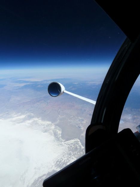
Because our pilot had a ton of transit time between Dryden and our targets in Colorado, we asked him for a huge favor: We asked him to take photos for our project. Keep in mind that he is in a pressurized suit, so everything he does, he does wearing bulky gloves. So we were very happy when he returned these amazing photos. Phenomenal.
The pictures (above and below) were taken from 65,000 feet above sea level. At this elevation, you can clearly see the curvature of the earth. Additionally, you can see the thinning of the atmosphere (apparent in the change in color of the sky from light blue to dark blue).


April 5, 2011
Credit: NASA/Tom Ryan
Specifically, we targeted a field that usually holds snow late in the season. Additionally, we targeted SNOwpack TELemetry (SNOTEL sites), where we have good control with respect to snow cover. One last site we targeted was a SNOTEL site situated within Loveland Ski Area, which was reporting one new inch of snow in the past 24 hours.
The weather looked slightly spotty to the north, but the pilot reported that there were clear skies over our targets!
We can actually receive limited information from the instruments during flight. So during the flight we knew that MABEL was operating properly. Additionally, we can get a very good sense of the cloud cover by looking at real-time data from an instrument that is flying along-side MABEL. It’s called CPL, or Cloud Physics Lidar. CPL records a smaller volume of data and has very mature software, relative to MABEL. So it’s easy to use CPL as a real-time assessment of atmospheric conditions during the flight. So we tend to fly CPL regularly with MABEL.
Because our pilot had a ton of transit time between Dryden and our targets in Colorado, we asked him for a huge favor: We asked him to take photos for our project. Keep in mind that he is in a pressurized suit, so everything he does, he does wearing bulky gloves. So we were very happy when he returned these amazing photos. Phenomenal.
The pictures (above and below) were taken from 65,000 feet above sea level. At this elevation, you can clearly see the curvature of the earth. Additionally, you can see the thinning of the atmosphere (apparent in the change in color of the sky from light blue to dark blue).
Credit: NASA/Tom Ryan
Credit: NASA/Tom Ryan
Credit: NASA/Tom Ryan
Over the Sierras, Third Flight’s a Charm
April 4th, 2011 by Kelly Brunt MABEL: Flying on a high-altitude aircraft at the brink of space, the MABEL instrument is helping scientists to simulate measurements from NASA’s next ice-observing satellite, ICESat-2.
April 4, 2011
Palmdale, Calif. – Well, it took three tries, but we finally collected excellent MABEL data over a forested area in the Sierras.
While we were flying the first attempt (3/28), the detector temperature kept drifting out of the acceptable thermal range. So MABEL would temporarily shut down to cool itself. The temperature for the detector has to be remain very close to 32
degrees, so we need to keep very close control over the temperature of the instrument. After landing, it was determined that the problem stemmed from the fact that MABEL’s cooling system had not been completely flushed. That was fixed for the next flight.
At some point during the second flight over the Sierras (3/29), MABEL’s GPS failed. We use the GPS signal for precise positioning, but we also use it for very precise time. GPS satellites broadcast very precise time (which is also exploited by seismologists). We use the GPS signal to measure the exact time between the laser firing and the detector receiving that signal. So without the GPS data, our laser data was pretty much worthless.
Instrument issues are common during deployments. The engineers associated with MABEL are quick to address them so that the week’s flight schedule stays intact.

 The third flight to the Sierras (3/30) was the clearest weather that MABEL had ever seen! It was what we had always been told was standard ‘southern California weather.’ And the flight itself went off without a hitch.
We are interested in a forest in the Sierras to assess MABEL’s ability to measure the top of the trees (the top of the tree canopy) and the ground beneath. These measurements give vegetation scientists an assessment of the biomass associated with these particular trees, which are evergreens. Later in the mission, we will try to collect similar data over Arkansas, or deciduous vegetation. Information from these flights will be incorporated into ICESat-2′s algorithms.
More from Dryden later!
April 4, 2011
Palmdale, Calif. – Well, it took three tries, but we finally collected excellent MABEL data over a forested area in the Sierras.
While we were flying the first attempt (3/28), the detector temperature kept drifting out of the acceptable thermal range. So MABEL would temporarily shut down to cool itself. The temperature for the detector has to be remain very close to 32
degrees, so we need to keep very close control over the temperature of the instrument. After landing, it was determined that the problem stemmed from the fact that MABEL’s cooling system had not been completely flushed. That was fixed for the next flight.
At some point during the second flight over the Sierras (3/29), MABEL’s GPS failed. We use the GPS signal for precise positioning, but we also use it for very precise time. GPS satellites broadcast very precise time (which is also exploited by seismologists). We use the GPS signal to measure the exact time between the laser firing and the detector receiving that signal. So without the GPS data, our laser data was pretty much worthless.
Instrument issues are common during deployments. The engineers associated with MABEL are quick to address them so that the week’s flight schedule stays intact.
In the photos attached, Eugenia DeMarco, of Sigma Space Corp., works in the nose cone, where MABEL rides. Credit: Ryna Cargo, Sigma Space Corp.
Dan Reed, of Sigma Space Corp., and Andrew Kupchock, of SSAI, diagnose MABEL while the pilot readies for take off.
We are interested in a forest in the Sierras to assess MABEL’s ability to measure the top of the trees (the top of the tree canopy) and the ground beneath. These measurements give vegetation scientists an assessment of the biomass associated with these particular trees, which are evergreens. Later in the mission, we will try to collect similar data over Arkansas, or deciduous vegetation. Information from these flights will be incorporated into ICESat-2′s algorithms.
More from Dryden later!
MABEL’s Second 2011 Flight
March 28th, 2011 by Kelly BruntMABEL: Flying on a high-altitude aircraft at the brink of space, the MABEL instrument is helping scientists to simulate measurements from NASA’s next ice-observing satellite, ICESat-2.
Palmdale, Calif. – MABEL had a very successful second flight on March 24!
Taking off from NASA’s Dryden Aircraft Operations Facility in Palmdale, Calif., we flew a second flight over the region for what we call our ‘shakedown’ mission.
This time, we flew targets in reverse direction to ensure that we had quality data over the open ocean. Our pilot flew southwest over the ocean until he found breaks in the morning marine layer, typical off of the coast of California. Once MABEL was back over land, the pilot reported that the weather was completely clear for the rest of the mission, which extended as far east as Lake Mead.
For this flight, we are testing some of MABEL’s unique capabilities, such as her variable field of view. This ‘shakedown’ mission is allowing us to assess that capability.

Dan Reed, of Sigma Space Corp., checks MABEL's flight software prior to this mission. Credit: Ryan Cargo, Sigma Space Corp.

The ER-2 is pushed out of the hanger for flight. Credit: Eugenia DeMarco, Sigma Space Corp.
You have an alphabetical guide in the foot of the page in the blog: solitary dog sculptor
In the blog: Solitary Dog Sculptor I, the alphabetical guide is on the right side of the page
Thanks
Usted tiene una guía alfabética al pie de la página en el blog: solitary dog sculptor
En el blog: Solitary Dog Sculptor I, la guia alfabética está en el costado derecho de la página
Gracias
Ricardo M Marcenaro - Facebook
Blogs in operation of The Solitary Dog:
solitary dog sculptor:
http://byricardomarcenaro.blogspot.com
Solitary Dog Sculptor I:
http://byricardomarcenaroi.blogspot.com
Para:
comunicarse conmigo,
enviar materiales para publicar,
propuestas comerciales:
marcenaroescultor@gmail.com
For:
contact me,
submit materials for publication,
commercial proposals:
marcenaroescultor@gmail.com
Diario La Nación
Argentina
Cuenta Comentarista en el Foro:
Capiscum
My blogs are an open house to all cultures, religions and countries. Be a follower if you like it, with this action you are building a new culture of tolerance, open mind and heart for peace, love and human respect.
Thanks :)
Mis blogs son una casa abierta a todas las culturas, religiones y países. Se un seguidor si quieres, con esta acción usted está construyendo una nueva cultura de la tolerancia, la mente y el corazón abiertos para la paz, el amor y el respeto humano.
Gracias :)

Comments (0)
Publicar un comentario