NASA: Canada - Wildfire Smoke Reaches the Atlantic - A Vertical View of Wildfire Smoke as it Heads to Sea - North American Smoke over Spain - Fires in Manitoba - 21.07.13
Posted by Ricardo Marcenaro | Posted in NASA: Canada - Wildfire Smoke Reaches the Atlantic - A Vertical View of Wildfire Smoke as it Heads to Sea - North American Smoke over Spain - Fires in Manitoba - 21.07.13 | Posted on 19:32

acquired June 23, 2013
download large image (4 MB, JPEG, 7000x5200)
acquired June 23, 2013
download GeoTIFF file (44 MB, TIFF)
acquired June 23, 2013
download Google Earth file (KMZ)
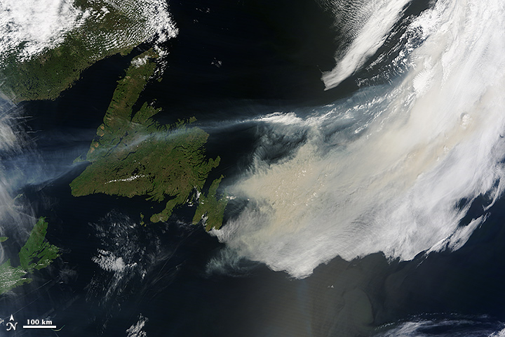
On June 23, 2013, the Moderate Resolution Imaging Spectroradiometer (MODIS) on NASA’s Terra
satellite captured this image of wildfire smoke over the North Atlantic
Ocean near Newfoundland. The smoke has a yellow-tan or milky gray color
compared with brighter white clouds.
Data from other satellites suggests that the smoke originated from wildfires in Canada; it is less likely, but possible, that it came from wildfires in Colorado and other parts of the southwestern United States.
Data from other satellites suggests that the smoke originated from wildfires in Canada; it is less likely, but possible, that it came from wildfires in Colorado and other parts of the southwestern United States.
NASA image by Jeff Schmaltz, LANCE/EOSDIS Rapid Response. Caption by Mike Carlowicz.
- Instrument:
- Terra - MODIS

acquired June 23, 2013
download large image (5 MB, JPEG, 8000x8000)
acquired June 23, 2013
download GeoTIFF file (130 MB, TIFF)
Meteorologists closely monitor smoke plumes from wildfires because smoke can spread across vast distances and pose significant health hazards, particularly to children and the elderly. With numerous wildfires burning in North America in June 2013, there has been plenty to keep smoke-watchers busy.
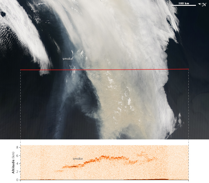
Understanding how high wildfires send smoke into the atmosphere is key to predicting where and how a plume will spread. Smoke lofted above the boundary layer—the part of the atmosphere closest to the ground, where topography has a significant impact on winds—will spread farther than smoke that remains trapped near the surface.
The images above offer two views of smoke from a large wildfire that was burning in Quebec, Canada, in June 2013. Several satellites observed the smoke plume as it was moving east over Newfoundland toward the Atlantic Ocean.
The background (top) image was captured by the Moderate Resolution Imaging Spectroradiometer (MODIS) on NASA’s Aqua satellite at 1:05 local time (16:05 Universal Time) on June 23, 2013. It shows a true-color view of the smoke plume from above. The image has been rotated so that north is to the left; this is to line the image up with the north-south flight path (marked in red) of the CALIPSO satellite.
The lower image is based on data acquired at 1:14 p.m. local time (16:14 UTC) by the Cloud-Aerosol Lidar with Orthogonal Polarization (CALIOP) instrument on CALIPSO. The instrument sent pulses of laser light (lidar) down through the atmosphere and recorded the reflections to generate a vertical profile of the smoke plume. The sensor detected smoke between about 2 and 6 kilometers (1.2 and 3.7 miles)—high enough that some of it was above the boundary layer. The height of the boundary layer varies, but it generally extends to a maximum of a few kilometers in eastern Canada.
Once the smoke was above the boundary layer, winds transported it east over the Atlantic Ocean. The MODIS instruments on NASA’s Aqua and Terra satellites acquired imagery of the smoke moving across the Atlantic on June 24, and June 25. By June 26, the smoke had reached western Europe. By June 27, it was over the Mediterranean Sea.
Occasionally, wildfires generate enough convection to send smoke plumes out of the troposphere and into the stratosphere, a layer of the atmosphere that generally begins between 8 and 16 kilometers (5 and 9 miles) from the surface.
References
- Natural Resources Canada Canadian Wildland Information System. Accessed June 27, 2013.
- University of Wisconsin, Cooperative Institute for Meteorological Satellite Studies (2013, June 22) Large fire in southeastern Quebec. Accessed June 27, 2013.
NASA Earth Observatory image by Jesse Allen, using expediated data provided by the CALIPSO
team. Caption by Adam Voiland, with information from Scott Bachmeier
(University of Wisconsin), Colin Seftor (NASA GSFC), and Rene Servranckx
(Canadian Meteorological Centre).
- Instrument:
- CALIPSO - CALIOP

acquired June 27, 2013
download large image (5 MB, JPEG, 8000x6000)
acquired June 27, 2013
download GeoTIFF file (68 MB, TIFF)
acquired June 27, 2013
download Google Earth file (KMZ)
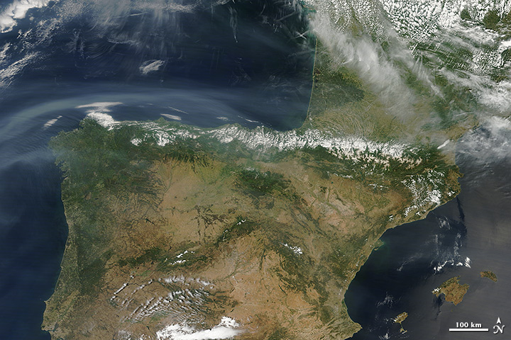
On June 27, 2013, the Moderate Resolution Imaging Spectroradiometer (MODIS) on NASA’s Terra
satellite captured this image of smoke plumes hovering over Spain and
the western Mediterranean Sea. The smoke has a faintly yellow-tan or
milky gray color compared with brighter white clouds. Open the larger image to see how the smoke extends over the open water.
Data from NASA and other satellites suggests that the smoke originated from wildfires in Canada; it is less likely, but possible, that it came from wildfires in Colorado and other parts of the southwestern United States.
Data from NASA and other satellites suggests that the smoke originated from wildfires in Canada; it is less likely, but possible, that it came from wildfires in Colorado and other parts of the southwestern United States.
NASA image by Jeff Schmaltz, LANCE/EOSDIS Rapid Response. Caption by Mike Carlowicz.
- Instrument:
- Terra - MODIS

acquired June 26, 2013
download large image (2 MB, JPEG, 3000x2200)
acquired June 26, 2013
download GeoTIFF file (11 MB, TIFF)
acquired June 26, 2013
download Google Earth file (KMZ)
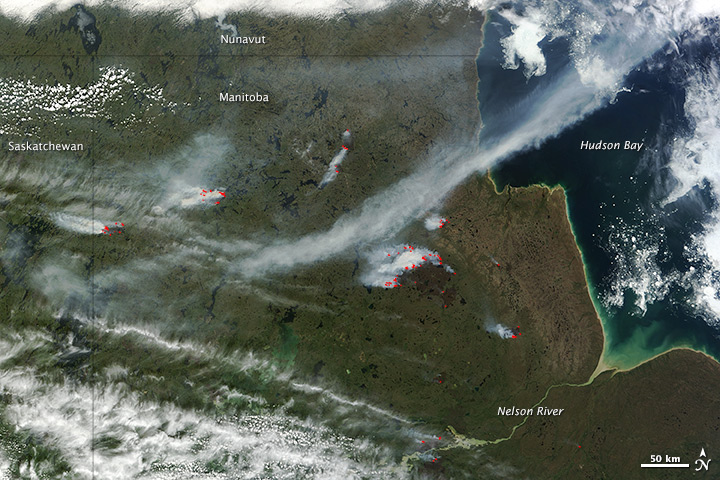
On June 26, 2013, the Moderate Resolution Imaging Spectroradiometer (MODIS) on NASA’s Terra
satellite captured this image of wildfires just west of Hudson Bay, in
central Canada’s Manitoba Province. Red outlines indicate hot spots
where MODIS detected unusually warm surface temperatures associated with
fire. The image is centered at 97° West longitude and 58.5° North
latitude.
NASA image by Jeff Schmaltz, LANCE/EOSDIS Rapid Response. Caption by Mike Carlowicz.
- Instrument:
- Terra - MODIS
NASA: Canada - Wildfire Smoke Reaches the Atlantic - A Vertical View of Wildfire Smoke as it Heads to Sea - North American Smoke over Spain - Fires in Manitoba - 21.07.13
You have an alphabetical guide in the foot of the page in the blog: solitary dog sculptor
In the blog: Solitary Dog Sculptor I, the alphabetical guide is on the right side of the page
Thanks
Usted tiene una guía alfabética al pie de la página en el blog: solitary dog sculptor
En el blog: Solitary Dog Sculptor I, la guia alfabética está en el costado derecho de la página
Gracias
Ricardo M Marcenaro - Facebook
Blogs in operation of The Solitary Dog:
solitary dog sculptor:
http://byricardomarcenaro.blogspot.com
Solitary Dog Sculptor I:
http://byricardomarcenaroi.blogspot.com
Para:
comunicarse conmigo,
enviar materiales para publicar,
propuestas comerciales:
marcenaroescultor@gmail.com
For:
contact me,
submit materials for publication,
commercial proposals:
marcenaroescultor@gmail.com
My blogs are an open house to all cultures, religions and countries. Be a follower if you like it, with this action you are building a new culture of tolerance, open mind and heart for peace, love and human respect.
Thanks :)
Mis blogs son una casa abierta a todas las culturas, religiones y países. Se un seguidor si quieres, con esta acción usted está construyendo una nueva cultura de la tolerancia, la mente y el corazón abiertos para la paz, el amor y el respeto humano.
Gracias :)


Comments (0)
Publicar un comentario