NASA: USA - Simcoe Mountains northeast of Goldendale - Washington - Mile Marker 28 Fire, 31.07.13
Posted by Ricardo Marcenaro | Posted in NASA: USA - Simcoe Mountains northeast of Goldendale - Washington - Mile Marker 28 Fire - 31.07.13 | Posted on 18:49

acquired July 28, 2013
download large image (5 MB, JPEG, 6900x4600)
acquired July 28, 2013
download GeoTIFF file (45 MB, TIFF)

acquired July 28, 2013
Eight major wildfires burned through forests and grasslands in the Pacific Northwest
in late-July 2013, threatening homes and forcing road closings and
evacuations. Many parts of Washington and Oregon faced extreme fire
threats, as strong thunderstorms lined up to hit parched forests and
grasslands with lightning.
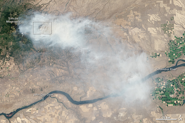
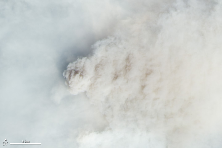
On July 28, 2013, the Operational Land Imager (OLI) on Landsat 8 captured these images of the Mile Marker 28 fire in the Simcoe Mountains northeast of Goldendale, Washington.
Smoke blew east toward Kennewick, Pasco, and Richland. The lower image
shows a closer view of smoke billowing up from the most active part of
the fire.
Ignited on July 24, 2013, the fire charred more than 22,000 acres
(8,900 hectares) by July 30, when more than 1,000 firefighters achieved
40 percent containment. The blaze forced the evacuation of dozens of
homes and the closure of US Highway 97.
Through July 25, 450 wildfires had burned 10,220 acres (4,136
hectares) in Washington, while Oregon saw 603 fires that burned 63,135
acres (25,549 hectares). In all, 2.3 million acres burned across the
United States by late-July, below the national average. Over the past
ten years, an average of 4.2 million acres had burned in the United
States by the end of each July.
While coastal and western Washington receive heavy rain throughout the year, the rain shadow
caused by the Cascades leaves central Washington quite dry. The
mountains force moist air from the Pacific to rise, causing it to cool
and condense into rain or snow on the windward side
of the Cascades. So little moisture is left by the time air passes over
the Cascades, that the area around Mile Marker 28 typically receives
just 8 inches (20 centimeters) of precipitation per year.
Further Reading
- Inciweb (2013, July 30) Mile 28 Marker Fire. Accessed July 30, 2013.
- National Interagency Fire Center (2013, July 30) Year-to-date Statistics. Accessed July 30, 2013.
- Tri-City Herald (2013, July 28) Goldendale wildfire up to nearly 27 square miles. Accessed July 30, 2013.
- The Oregonian (2013, July 30) Goldendale wildfire up to nearly 27 square miles. Accessed July 30, 2013.
Further Reading
- NASA Earth Observatory (2012, September 23) Oregon Rain Shadow.
NASA Earth Observatory image by Jesse Allen and Robert Simmon, using Landsat data from the U.S. Geological Survey. Caption by Adam Voiland
- Instrument:
- Landsat 8 - OLI
NASA: USA - Simcoe Mountains northeast of Goldendale - Washington - Mile Marker 28 Fire, 31.07.13
Ricardo M Marcenaro - Facebook
Blogs in operation of The Solitary Dog:
Solitary Dog Sculptor:
http://byricardomarcenaro.blogspot.com
Solitary Dog Sculptor I:
http://byricardomarcenaroi.blogspot.com
Para:
comunicarse conmigo,
enviar materiales para publicar,
propuestas comerciales:
marcenaroescultor@gmail.com
For:
contact me,
submit materials for publication,
commercial proposals:
marcenaroescultor@gmail.com
My blogs are an open house to all cultures, religions and countries. Be a follower if you like it, with this action you are building a new culture of tolerance, open mind and heart for peace, love and human respect.
Thanks :)
Mis blogs son una casa abierta a todas las culturas, religiones y países. Se un seguidor si quieres, con esta acción usted está construyendo una nueva cultura de la tolerancia, la mente y el corazón abiertos para la paz, el amor y el respeto humano.
Gracias :)


Comments (0)
Publicar un comentario