NASA: Democratic Republic of the Congo - Nyamuragira volcano - Journey from the Center of the Earth - 17.07.13
Posted by Ricardo Marcenaro | Posted in NASA: Democratic Republic of the Congo - Nyamuragira volcano - Journey from the Center of the Earth - 17.07.13 | Posted on 18:17
Open your mind, your heart to other cultures
Abra su mente, su corazón a otras culturas
You will be a better person
Usted será una mejor persona
RM
Abra su mente, su corazón a otras culturas
You will be a better person
Usted será una mejor persona
RM

acquired June 11, 2013
download large image (6 MB, JPEG, 6552x4368)
acquired June 11, 2013
download GeoTIFF file (39 MB, TIFF)

acquired June 11, 2013
download large image (3 MB, JPEG, 3276x2184)
acquired June 11, 2013
download GeoTIFF file (16 MB, TIFF)
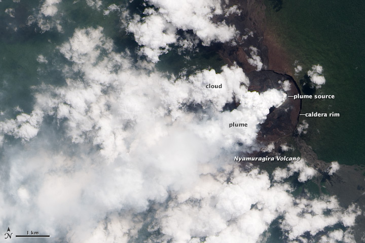
A thick plume rose from the summit of Nyamuragira volcano
in June 2013. Located near the eastern boundary of the Democratic
Republic of the Congo, Nyamuragira is one of Africa’s most active
volcanoes. Its plume is rich in water vapor—which condenses rapidly in
the humid tropical air—and sulfur dioxide, which lends a blue tint in
natural-color satellite imagery (top). Carbon dioxide, fluorine, and
chlorine gas are also found in Nyamuragira lavas and likely present in the gas plume.
The source of the plume appears to be a pit nestled within the
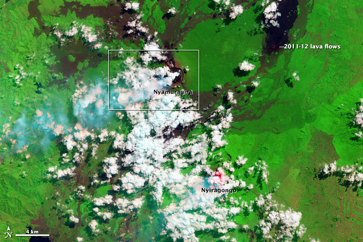
caldera that tops Nyamuragira. If outgassing magma was near the surface,
then the intense heat would cause a bright red glow in shortwave
infrared light (included in the lower, false-color image). No such glow
is visible atop Nyamuragira, but it is present on neighboring Nyiragongo Volcano, which has featured a lava lake for more than a decade.
These images were collected on June 11, 2013, by the Operational Land Imager
on Landsat 8. In natural color (top), the rainforest is dark green,
clouds are white, and the sulfur-rich volcanic plume is very light blue.
Barren land at Nyamuragira’s summit and lava flows are brown or black.
In false-color, clouds are mostly white and volcanic plumes are cyan.
Forest and other vegetation is bright green. Fresh lava flows from the 2011–12 eruption
of Nyamuragira are black, and older lava flows appear as brown tendrils
running down the mountain’s flanks. Agricultural fields in the
southeast (lower right) corner of the image also appear brown.
NASA Earth Observatory images by Jesse Allen and Robert Simmon, using Landsat 8 data from the USGS Global Visualization Viewer. Caption by Robert Simmon.
- Instrument:
- Landsat 8 - OLI
NASA: Democratic Republic of the Congo - Nyamuragira volcano - Journey from the Center of the Earth - 17.07.13
You have an alphabetical guide in the foot of the page in the blog: solitary dog sculptor
In the blog: Solitary Dog Sculptor I, the alphabetical guide is on the right side of the page
Thanks
Usted tiene una guía alfabética al pie de la página en el blog: solitary dog sculptor
En el blog: Solitary Dog Sculptor I, la guia alfabética está en el costado derecho de la página
Gracias
Ricardo M Marcenaro - Facebook
Blogs in operation of The Solitary Dog:
solitary dog sculptor:
http://byricardomarcenaro.blogspot.com
Solitary Dog Sculptor I:
http://byricardomarcenaroi.blogspot.com
Para:
comunicarse conmigo,
enviar materiales para publicar,
propuestas comerciales:
marcenaroescultor@gmail.com
For:
contact me,
submit materials for publication,
commercial proposals:
marcenaroescultor@gmail.com
My blogs are an open house to all cultures, religions and countries. Be a follower if you like it, with this action you are building a new culture of tolerance, open mind and heart for peace, love and human respect.
Thanks :)
Mis blogs son una casa abierta a todas las culturas, religiones y países. Se un seguidor si quieres, con esta acción usted está construyendo una nueva cultura de la tolerancia, la mente y el corazón abiertos para la paz, el amor y el respeto humano.
Gracias :)


Comments (0)
Publicar un comentario