NASA: USA - Aftermath of Colorado’s Most Destructive Wildfire - Canada - Quebec - A Vertical View of Wildfire Smoke as it Heads to Sea - 11.07.13
Posted by Ricardo Marcenaro | Posted in NASA: USA - Aftermath of Colorado’s Most Destructive Wildfire - Canada - Quebec - A Vertical View of Wildfire Smoke as it Heads to Sea - 11.07.13 | Posted on 18:34

acquired June 21, 2013
download large image (5 MB, JPEG, 3408x3408)
acquired June 21, 2013
download GeoTIFF file (29 MB, TIFF)

acquired June 20, 2013
download large image (428 KB, JPEG, 2100x1500)
acquired June 21, 2013
download Google Earth file (KML)
The first 911 call for the Black Forest fire
came on June 11, 2013. Nine days later, firefighters had fully
contained the blaze, but not before it had devastated a wooded suburb of
Colorado Springs, Colorado. The fire charred more than 14,000 acres
(5,700 hectares), destroying 509 homes and killing two people. The Black
Forest fire was the most destructive in the state’s history, eclipsing
the Waldo Canyon fire that struck another part of the Colorado Springs area in 2012.
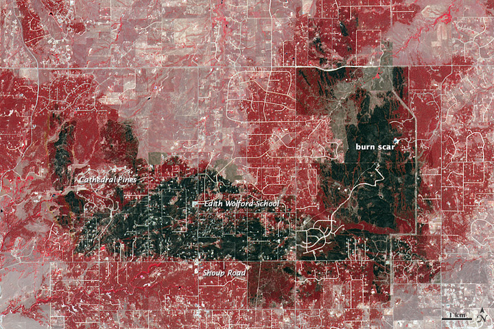
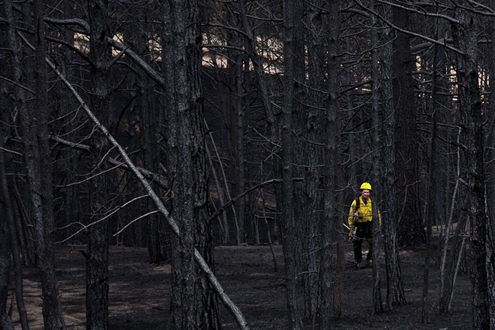
The Advanced Spaceborne Thermal Emission and Reflection Radiometer (ASTER) on the Terra satellite acquired this view of the burn scar on June 21, 2013. Vegetation-covered land is red in the false-color image, which includes both visible and infrared light. Patches of unburned forest are bright red. Unburned grasslands are pink. The darkest gray and black areas are the most severely burned. Buildings, roads, and other developed areas appear light gray and white. The lower image, a photograph taken on June 20, shows a charred section of Black Forest.
The most severe damage occurred north of Shoup Road, but the severity varied widely by neighborhood. Cathedral Pines, for instance, escaped largely unscathed. Many residents of that neighborhood put rocks around their homes, removed vegetation and dead trees from their yards, avoided using mulch, and followed other fire prevention strategies that helped keep flames back long enough for fighters to save homes, the Denver Post reported.
One key building that escaped the flames was Edith Wolford elementary school. Though it was in the middle of an area that was severely burned, the school survived intact partly because of the large, treeless parking lot surrounding it.
References
- Denver Post (2013, June 21) Fire mitigation measures saved some Black Forest homes. Accessed June 25, 2013.
- InciWeb (2013, June 25) Black Forest Fire. Accessed June 25, 2013.
- The Gazette (2013, June 21) ‘A reason the schools survived:’ Campuses feared lost in Black Forest fire are largely unscathed. Accessed June 25, 2013.
NASA Earth Observatory image by Jesse Allen and Robert Simmon, using data from NASA/GSFC/METI/ERSDAC/JAROS, and U.S./Japan ASTER Science Team. Lower photograph courtesy of the Great Basin National Incident Management Team. Caption by Adam Voiland.
- Instrument:
- Terra - ASTER
A Vertical View of Wildfire Smoke as it Heads to Sea

acquired June 23, 2013
download large image (5 MB, JPEG, 8000x8000)
acquired June 23, 2013
download GeoTIFF file (130 MB, TIFF)
Meteorologists closely monitor smoke plumes from wildfires because smoke can spread across vast distances and pose significant health hazards, particularly to children and the elderly. With numerous wildfires burning in North America in June 2013, there has been plenty to keep smoke-watchers busy.
Understanding how high wildfires send smoke into the atmosphere is
key to predicting where and how a plume will spread. Smoke lofted above
the boundary layer—the
part of the atmosphere closest to the ground, where topography has a
significant impact on winds—will spread farther than smoke that remains
trapped near the surface.
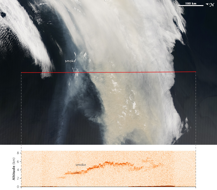
The images above offer two views of smoke from a large wildfire
that was burning in Quebec, Canada, in June 2013. Several satellites
observed the smoke plume as it was moving east over Newfoundland toward
the Atlantic Ocean.
The background (top) image was captured by the Moderate Resolution Imaging Spectroradiometer (MODIS) on NASA’s Aqua
satellite at 1:05 local time (16:05 Universal Time) on June 23, 2013.
It shows a true-color view of the smoke plume from above. The image has
been rotated so that north is to the left; this is to line the image up
with the north-south flight path (marked in red) of the CALIPSO satellite.
The lower image is based on data acquired at 1:14 p.m. local time (16:14 UTC) by the Cloud-Aerosol Lidar with Orthogonal Polarization (CALIOP) instrument on CALIPSO. The instrument sent pulses of laser light (lidar)
down through the atmosphere and recorded the reflections to generate a
vertical profile of the smoke plume. The sensor detected smoke between
about 2 and 6 kilometers (1.2 and 3.7 miles)—high enough that some of it
was above the boundary layer. The height of the boundary layer varies,
but it generally extends to a maximum of a few kilometers in eastern
Canada.
Once the smoke was above the boundary layer, winds transported it
east over the Atlantic Ocean. The MODIS instruments on NASA’s Aqua and Terra satellites acquired imagery of the smoke moving across the Atlantic on June 24, and June 25. By June 26, the smoke had reached western Europe. By June 27, it was over the Mediterranean Sea.
Occasionally, wildfires generate enough convection to send smoke plumes out of the troposphere and into the stratosphere, a layer of the atmosphere that generally begins between 8 and 16 kilometers (5 and 9 miles) from the surface.
References
- Natural Resources Canada Canadian Wildland Information System. Accessed June 27, 2013.
- University of Wisconsin, Cooperative Institute for Meteorological Satellite Studies (2013, June 22) Large fire in southeastern Quebec. Accessed June 27, 2013.
NASA Earth Observatory image by Jesse Allen, using expediated data provided by the CALIPSO
team. Caption by Adam Voiland, with information from Scott Bachmeier
(University of Wisconsin), Colin Seftor (NASA GSFC), and Rene Servranckx
(Canadian Meteorological Centre).
- Instrument:
- CALIPSO - CALIOP
Ricardo M Marcenaro - Facebook
Blogs in operation of The Solitary Dog:
Solitary Dog Sculptor:
byricardomarcenaro.blogspot.com
Solitary Dog Sculptor I:
byricardomarcenaroi.blogspot.com/
Para:
comunicarse conmigo
comunicarse conmigo
marcenaroescultor@gmail.com
For:
contact me
For:
contact me
marcenaroescultor@gmail.com
My blogs are an open house to all cultures, religions and countries. Be a follower if you like it, with this action you are building a new culture of tolerance, open mind and heart for peace, love and human respect. Thanks :)
Mis blogs son una casa abierta a todas las culturas, religiones y países. Se un seguidor si quieres, con esta acción usted está construyendo una nueva cultura de la tolerancia, la mente y el corazón abiertos para la paz, el amor y el respeto humano. Gracias:)
(::)


Comments (0)
Publicar un comentario