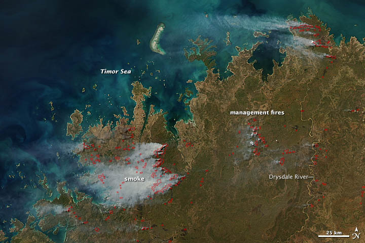
Nasa: Fires in Western Australia - 05.05.12
Posted by Ricardo Marcenaro | Posted in Nasa: Fires in Western Australia - 05.05.12 | Posted on 16:00

acquired May 2, 2012
download large image (507 KB, JPEG, 2800x2200)
When this image was captured by the Moderate Resolution Imaging Spectroradiometer (MODIS) instrument on NASA’s Aqua satellite
at 12:20 p.m. local time (5:20 Universal Time) on May 2, 2012, dozens
of fires, most likely management fires started by government
authorities, were burning in the Kimberely region of Western Australia.
Fire season in this part of Australia usually begins in May and ends in November. Once started, wildfires can be difficult to control. Much of the vegetation is fire prone, and the terrain is hard to access with big machines, such as bulldozers, used to extinguish fires. But since May is only the beginning of the dry season, vegetation is still relatively moist, and fires are relatively easy to contain. Authorities take advantage of this by starting management fires that are designed to remove vegetation that could fuel large wildfires later in the season.
On May 1, 2012, the Australian Bureau of Meteorology released rainfall figures for the just-completed wet season in Western Australia. In Kimberley, rainfall was above average; Dampier Downs in Kimberley experienced its wettest wet season on record, with more than 864 millimeters (34 inches) of rain. Extra rain during the wet season typically leads to a more vigorous plant growth, which provides more fuel for the fire season later in the year.
Because officials are concerned that wildfires are taking a toll on the local tourism industry, they have intensified their efforts to prevent damaging wildfires with management fires. As part of this effort, they have begun setting patches of oval-shaped management fires rather than burning linear fire breaks as they did in the past, according to an article published by Australian Geographic. The new approach has reduced the overall fire size, and posed fewer threats to animals and plants in the Kimberley region.
Fires continued to burn in the region over the next several days, although clouds moved in around May 6, 2012. The LANCE MODIS Rapid Response system provides twice daily images of northwestern Australia.
References
- 9News. (2012) Prescribed Burns Begin in WA’s Kimberley. Accessed May 4, 2012.
- Laurie, V. (2010) Radical Fire Plan for Kimberely. Australian Geographic Accessed
- MODIS Image of the Day. (2012) Fires in Northern Australia. Accessed May 4, 2012.
- Western Australia Government Department of Environment and Conservation. Principles of fire management in savanna landscapes of the Kimberley. Accessed May 7, 2012.
NASA image by Jeff Schmaltz, LANCE MODIS Rapid Response. Caption by Adam Voiland and Michon Scott.
- Instrument:
- Aqua - MODIS
You have an alphabetical guide in the foot of the page in the blog: solitary dog sculptor
In the blog: Solitary Dog Sculptor I, the alphabetical guide is on the right side of the page
Thanks
Usted tiene una guía alfabética al pie de la página en el blog: solitary dog sculptor
En el blog: Solitary Dog Sculptor I, la guia alfabética está en el costado derecho de la página
Gracias
Ricardo M Marcenaro - Facebook
Blogs in operation of The Solitary Dog:
solitary dog sculptor:
http://byricardomarcenaro.blogspot.com
Solitary Dog Sculptor I:
http://byricardomarcenaroi.blogspot.com
Para:
comunicarse conmigo,
enviar materiales para publicar,
propuestas comerciales:
marcenaroescultor@gmail.com
For:
contact me,
submit materials for publication,
commercial proposals:
marcenaroescultor@gmail.com
Diario La Nación
Argentina
Cuenta Comentarista en el Foro:
Capiscum
My blogs are an open house to all cultures, religions and countries. Be a follower if you like it, with this action you are building a new culture of tolerance, open mind and heart for peace, love and human respect.
Thanks :)
Mis blogs son una casa abierta a todas las culturas, religiones y países. Se un seguidor si quieres, con esta acción usted está construyendo una nueva cultura de la tolerancia, la mente y el corazón abiertos para la paz, el amor y el respeto humano.
Gracias :)


Comments (0)
Publicar un comentario