NASA: US - Arizona - More City. Less Green in Tucson - Texas - Dallas - First of Three Million - July 2012
Posted by Ricardo Marcenaro | Posted in NASA: US - Arizona - More City. Less Green in Tucson - Texas - Dallas - First of Three Million - July 2012 | Posted on 9:33

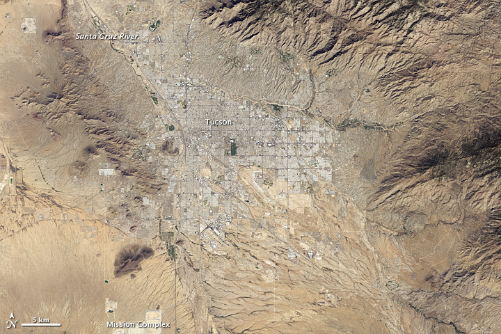
acquired October 28, 2011
download large image (2 MB, JPEG, 2673x2673)

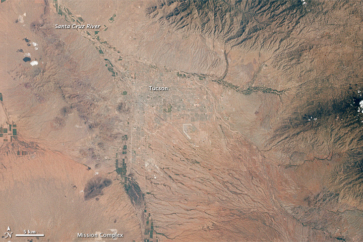
acquired August 22, 1965
download large image (1 MB, JPEG, 2673x2673)
The astronauts who snapped photos of Earth during the Mercury and Gemini missions produced more than just pretty pictures. They planted seeds at the U.S. Geological Survey (USGS) and NASA. In the mid-1960s, the director of USGS proposed a satellite program
to observe our planet from above, and later described Landsat as “a
direct result of the demonstrated utility of the Mercury and Gemini
orbital photography to Earth resource studies.”
On a week-long flight in late August 1965, Gemini V astronauts Gordon Cooper and Pete Conrad took photos of the Earth, including a shot showing Tucson, Arizona, the nearby Santa Cruz River, and cultivated fields along the riverbanks. A lot changed in the 46 years between that photo (lower image) and the satellite image (top) acquired in 2011 by the Thematic Mapper on Landsat 5.
A comparison of the images shows more city and less green. First, the expansion of urbanized areas is readily identifiable by the grid pattern of city streets. Between 1965 and 2011, Tucson’s population grew rapidly. In 1970, the population was 262,933; in 2010, it was 520,116.
Another difference between the images is the reduction in vegetated areas, especially south of the city and east of the Mission Complex mine. The Gemini photo was acquired in late August, whereas the Landsat image was acquired in late October, so some vegetation might have faded with advancing autumn. In addition, the Tucson region experienced drought conditions in 2011, which also may have reduced green vegetation.
But rapidly expanding cities in the American Southwest (such as Tucson) have another problem: a scarcity of fresh water. Tucson has met its water needs largely by pumping ground water, which has fed the city’s thirst since the 1940s. But as groundwater has been extracted faster than it can be replenished, water tables have lowered, riparian habitats have shrunk, and water quality has declined, according to a water-sustainability study from the City of Tucson and Pima County.
City and county officials were well aware of Tucson’s hydrological challenges by the time Landsat captured the 2011 scene. “Stream flow disappearance due to groundwater pumping, floodplain development, and habitat loss due to erosion have significantly altered the biologically rich and diverse riparian corridors of eastern Pima County,” stated a brochure from the Sonoran Desert Conservation Plan. Efforts designed to restore native habitat include planting native species on county lands, and capturing storm water to restore wetlands. Meanwhile, water-sustainability efforts aim to reduce groundwater-pumping rates. The long-term goal is that, by 2025, groundwater pumping should not exceed natural replenishment.
Read more about the 40-year-old Landsat program and its record of Earth changes in our new feature story: Landsat Looks and Sees.
-
References
- City of Tucson / Pima County. 2011–2015 Action Plan for Water Sustainability. Accessed July 13, 2012.
- Desert Ecology of Tucson, Arizona. Tucson’s Five Seasons. Pima Community College. Accessed July 20, 2012.
- Impact of Climate Change and Land Use in the Southwestern United States. (2004, May 18) Major floods and droughts in Arizona. U.S. Geological Survey. Accessed July 20, 2012.
- Landsat Program. (2012, July 10) From the Beginning. NASA Goddard Space Flight Center. Accessed July 13, 2012.
- March to the Moon. Arizona, Tucson and Vicinity. Arizona State University. Accessed July 20, 2012.
- NASA Earth Observatory (2012, July 23) Landsat Looks and Sees.
- National Weather Service, Tucson, Arizona. (2012, June 7) Southeast Arizona Drought Monitoring. National Oceanic and Atmospheric Administration. Accessed July 20, 2012.
- Pima Associated of Governments. Population Estimates. Accessed July 13, 2012.
- Project Gemini. (2000, August 25) Gemini-V (5). Kennedy Space Center. Accessed July 20, 2012.
- Sonoran Desert Conservation Plan. (2009) A Vision For Riparian Protection. Pima County, Arizona. Accessed July 13, 2012.
- Sonoran Desert Conservation Plan. Riparian Projects. Pima County, Arizona. Accessed July 13, 2012.
NASA Earth Observatory image created by Robert Simmon, using Landsat data provided by the United States Geological Survey. NASA Gemini V astronaut photo courtesy March to the Moon. Caption by Michon Scott.
- Instrument:
- Landsat 5 - TM

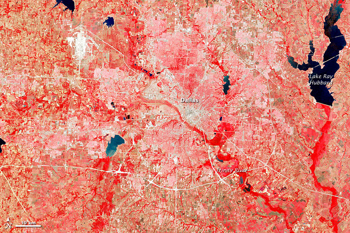
acquired July 25, 1972
download large image (3 MB, JPEG, 3127x3406)
Forty years ago, after more than a
decade working to leave our planet, NASA launched an unprecedented
mission to look back at home. Four decades later, the Landsat program is still going strong, with more than three million images of Earth in its archives and a new mission slated for launch in 2013.
On July 23, 1972, the Earth Resources Technology Satellite (later renamed Landsat 1) lifted off on a Thor-Delta (Delta 900) rocket from Vandenberg Air Force Base in California. The first images from the satellite’s Multispectral Scanner System (MSS) were received a day later by scientists gathered at NASA’s Goddard Space Flight Center in Maryland. The very first image in the Landsat archive is the MSS image above, showing the greater Dallas area of Texas on July 25, 1972. The resolution is 60 meters per pixel in this false-color image, where shades of red indicate vegetated land and grays and whites are urban or rocky surfaces.
Scientists involved in the mission weren't sure what to expect of the MSS, which used new fiber-optic technology, took pictures in four different bands of the spectrum, and scanned the Earth in strips. (More conventional television-style cameras—known as return beam vidicons (RBV)—had been expected to be the main workhorse of the satellite.) A group of scientists and technicians gathered at NASA Goddard with great anticipation, as the first MSS transmission was translated onto film by an electron beam recorder and then put into a viewing device.
As the imagery scrolled into view, there were clouds...and then more clouds...and then land. But something looked strange. A technician in the room lamented: “lt’s terrible. It has moiré patterns.” But after figuring out the location of the image—the Ouachita Mountain region in southeastern Oklahoma—scientists realized that the imagery was showing circular outcrops of the ancient fold mountains.
Any lingering anxiety in the room quickly turned to excitement, and skeptics were promptly converted into supporters. The well-known U.S. Geological Survey cartographer Alden Colvocoresses, who had been cynical about any cartographically accurate data being collected with “a little mirror in space,” turned to his colleagues after seeing the MSS imagery and said:“gentlemen, that’s a map.”
Read more about the history of the Landsat program in our new feature story: Landsat Looks and Sees.
NASA Earth Observatory image created by Robert Simmon, using Landsat data provided by the United States Geological Survey. Caption by Michael Carlowicz and Laura Rocchio.
- Instrument:
- Landsat 1 (ERTS)
NASA: US - Arizona - More City. Less Green in Tucson - Texas - Dallas - First of Three Million - July 2012
Ricardo M Marcenaro - Facebook
Operative blogs of The Solitary Dog:
solitary dog sculptor:
http://byricardomarcenaro.blogspot.com
Solitary Dog Sculptor I:
http://byricardomarcenaroi.blogspot.com
Para:
comunicarse conmigo,
enviar materiales para publicar,
propuestas:
marcenaroescultor@gmail.com
For:
contact me,
submit materials for publication,
proposals:
marcenaroescultor@gmail.com
Diario La Nación
Argentina
Cuenta Comentarista en el Foro:
Capiscum
My blogs are an open house to all cultures, religions and countries. Be a follower if you like it, with this action you are building a new culture of tolerance, open mind and heart for peace, love and human respect.
Thanks :)
Mis blogs son una casa abierta a todas las culturas, religiones y países. Se un seguidor si quieres, con esta acción usted está construyendo una nueva cultura de la tolerancia, la mente y el corazón abiertos para la paz, el amor y el respeto humano.
Gracias :)


Comments (0)
Publicar un comentario