NASA: Atlantic Ocean - North Africa in winter - Sharp Line in the Clouds - 10.03.13NASA: Atlantic Ocean - North Africa in winter - Sharp Line in the Clouds - 10.03.13
Posted by Ricardo Marcenaro | Posted in NASA: Atlantic Ocean - North Africa in winter - Sharp Line in the Clouds - 10.03.13 | Posted on 20:02
Fast-moving, cool air masses often
sweep from east to west across North Africa in the winter, sending
surges of dry air over the Atlantic Ocean. When this dry air encounters
moister and more stable air masses over the water, the clash can yield
distinctive and beautiful patterns in the clouds.
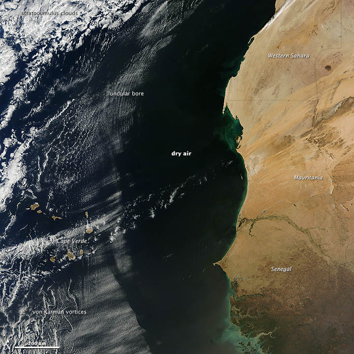
On February 18, 2013, the Moderate Resolution Imaging Spectroradiometer (MODIS) on NASA’s Terra satellite captured this view of a thin layer of marine stratocumulus clouds off the coast of western Africa.
The air mass moving west pushed a wave of cool, dry air ahead of it, much like the bow wave of water that moves ahead of a boat in calm water. When that wave of air met the mass of moist air over the ocean, it pushed the moist air up. As that air rose, it cooled at the peak of the wave, forming a linear wave cloud. As the wave propagated forward, it rose to a slightly lower peak, and so on and so forth, until it eventually dissipated. The series of clouds that formed at the high-altitude peaks produced the rippling pattern seen in the clouds. This type of atmospheric disturbance is known as an undular bore. The air to the east of the bore is almost completely cloud-free because dry air would have eroded any clouds in that area.
The Cape Verde islands had their own noticeable effect on the clouds to the south. Air masses passing over the volcanic islands split into streams, then come back together—a process that creates off-centered areas of low pressure like whirlpools. These low-pressure areas produce thread-like swirls in the clouds downstream of the islands. These are known as Von Karman vortices. The cloud layer is fairly thin in this image, so the vortices are less distinct than they are in other satellite images of the phenomenon.
References
- CIMSS Satellite Blog (2011, April 27) Undular bore over the Gulf of Mexico. Accessed February 27, 2013.
- NASA GES DISC (n.d.) Science Focus: Von Karman Vortices. Accessed Feb. 22, 2013.
- NASA (2007, Oct. 11) Giant Atmospheric Waves Sighted Over Iowa. Accessed Feb. 22, 2013.
- Washington Post (2010, Nov. 9) The mystery of the von Karman vortex street. Accessed February 27, 2013.
NASA image by Jeff Schmaltz, LANCE/EOSDIS MODIS Rapid Response. Caption by Adam Voiland, with information from Scott Bachmeier.
- Instrument:
- Terra - MODIS
- NASA: Atlantic Ocean - North Africa in winter - Sharp Line in the Clouds - 10.03.13


Comments (0)
Publicar un comentario