NASA: Volcanos - Savu Sea - Flores Island. Strong Eruption at Paluweh Volcano - Russia. Kamchatka Peninsula - Activity at Tolbachik - Activity at Kizimen Volcano - Italy. Etna Volcano - 27.03.13
Posted by Ricardo Marcenaro | Posted in NASA: Volcanos - Savu Sea - Flores Island. Strong Eruption at Paluweh Volcano - Russia. Kamchatka Peninsula - Activity at Tolbachik - Activity at Kizimen Volcano - Italy. Etna Volcano - 27.03.13 | Posted on 21:01
Strong Eruption at Paluweh Volcano
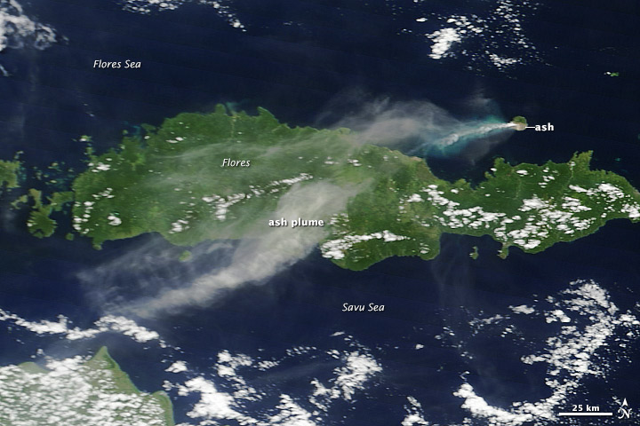
acquired March 24, 2013
download large image (108 KB, JPEG, 720x480)
acquired March 24, 2013
download GeoTIFF file (5 MB, TIFF)
Thick ash drifted over Flores Island and the Savu Sea after a strong explosion at Paluweh
(also known as Rokatenda) Volcano. Light-colored ash coated the
southern third of Paluweh Island, while the sea to the west was colored
turquoise by ash floating near the water’s surface. High-altitude winds
carried airborne ash more than 440 kilometers (270 miles) to the
southwest.
This natural-color satellite image was collected on March 24, 2013, by the Moderate Resolution Imaging Spectroradiometer (MODIS) on the Terra satellite.
This natural-color satellite image was collected on March 24, 2013, by the Moderate Resolution Imaging Spectroradiometer (MODIS) on the Terra satellite.
NASA image courtesy Jeff Schmaltz LANCE/EOSDIS MODIS Rapid Response Team, GSFC. Caption by Robert Simmon.
- Instrument:
- Terra - MODIS
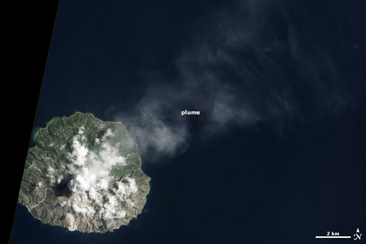
acquired March 26, 2013
download large image (1 MB, JPEG, 5037x5038)
acquired March 26, 2013
download GeoTIFF file (17 MB, TIFF)
Paluweh Volcano,
(also known as Rokatenda) one of Indonesia’s Lesser Sunda Islands,
emitted a plume of gas and ash on March 26, 2013. This natural-color
satellite image was collected by the Advanced Land Imager (ALI) on Earth Observing-1 (EO-1).
NASA Earth Observatory image by Jesse Allen and Robert Simmon, using EO-1 ALI data from the NASA EO-1 team. Caption by Robert Simmon.
- Instrument:
- EO-1 - ALI
Activity at Tolbachik
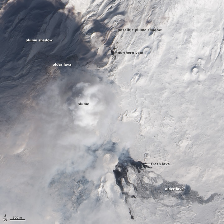
acquired March 20, 2013
download large image (5 MB, JPEG, 5285x5285)
Though some volcanic eruptions are
singular events—explosions of ash and lava that begin and end
suddenly—most ebb, flow, and evolve over time, as underground magma
shifts and underground channels open and close. For example, Kilauea has
experienced 60 distinct events during its ongoing, 30-year eruption, while Eyjafjallajökull switched from a mild, effusive eruption to a violent, explosive eruption in April 2010.
New satellite images in March 2013 revealed possible shifts in activity at Tolbachik volcano, in far eastern Russia. Tolbachik is a complex volcano on the Kamchatka Peninsula that has been erupting since late November 2012.
The eruption began with the opening of two fissures on Tolbachinsky Dol, a plateau south of the summits of Ostry Tolbachik and Plosky Tolbachik. Lava fountains spurted from the fissures, feeding lava flows that stretched at least 16.5 kilometers (10.3 miles) from their source. Within a week, emissions from the northern fissure had slowed or stopped, and the southern fissure coalesced into a single vent. Activity remained centered at the southern vent for three months.
On March 20, 2013, the natural-color satellite image above revealed a dark spot either at the site of the northern fissure or at the northern end of the original southern fissure. The area—about 290 meters (950 feet) north-south and 110 meters (360 feet) east-west— appears similar to the fresh lava flows pouring from the southern vent, and stands out from the surrounding snow. A dark shadow stretched northwest from the site, perhaps cast by a thin gas plume. These features suggest fresh lava is reaching the surface in a second location.
This image of Tolbachik was collected by the Advanced Land Imager (ALI) aboard the Earth Observing-1 (EO-1) satellite. A dense volcanic plume obscures the active southern vent, but fresh black lava flows are visible to the south. Older flows, covered in snow, reach further to the east. Flows dating from the initial days of the eruption stretch from the site labeled “northern vent” to the west, but are partially hidden by the plume and plume shadow. Volcanic cones from earlier eruptions (1970 and earlier) dot the landscape.
References
- Global Volcanism Program (2012, December) Index of Monthly Reports, Tolbachik. Accessed March 25, 2013.
- Kamchatka Volcanic Eruption Response Team (2013, March 24) VONA/KVERT Daily Report. Accessed March 25, 2013.
NASA Earth Observatory image by Jesse Allen and Robert Simmon, using EO-1 ALI data from the NASA EO-1 team. Caption by Robert Simmon.
- Instrument:
- EO-1 - ALI
Activity at Kizimen Volcano
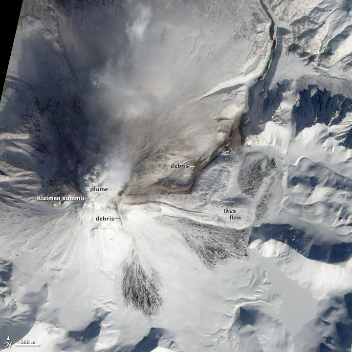
acquired March 12, 2013
download large image (1 MB, JPEG, 2629x2629)
acquired March 12, 2013
download GeoTIFF file (9 MB, TIFF)
Kizimen Volcano on Russia’s Kamchatka Peninsula remained active in March 2013. The Advanced Land Imager (ALI) on NASA’s Earth Observing-1
(EO-1) satellite captured this natural-color image on March 12. A plume
rose from the summit, while snow covered a lava flow on the volcano’s
eastern flank. That lava was actively advancing in February 2012, and still growing a year later.
Kizimen is a steep-sloped stratovolcano composed of alternating layers of volcanic ash, lava, and debris. According to the Global Volcanism Program at the Smithsonian Institution, Kizimen has a shape similar to Mount St. Helens prior to its 1980 eruption. Kizimen experienced a bout of eruptive activity in the late 1920s, then remained quiet for the rest of the 20th century. The volcano began showing signs of unrest in July 2009, with a swarm of seismic activity—up to 120 earthquakes a day. In November 2010, the volcano had a strong fissure eruption, and pyroclastic flows—avalanches of rocks and hot gases—began in February 2011.
Reports from the Kamchatka Volcanic Eruption Response Team noted that Kizimen experienced moderate seismic activity, incandescent lava extrusions, hot avalanches on the eastern and western flanks, and gas and steam eruptions in early March 2013.
References
- Global Volcanism Program Kizimen Summary, Monthly Reports, and Weekly Reports. Smithsonian Institution. Accessed March 14, 2013.
- Kamchatka Volcanic Eruption Response Team (2013, March 14) VONA/KVERT Daily Report Accessed March 14, 2013.
NASA Earth Observatory image created by Jesse Allen and Robert Simmon, using Advanced Land Imager data from the NASA EO-1 team. Caption by Michon Scott.
- Instrument:
- EO-1 - ALI
Mount Etna
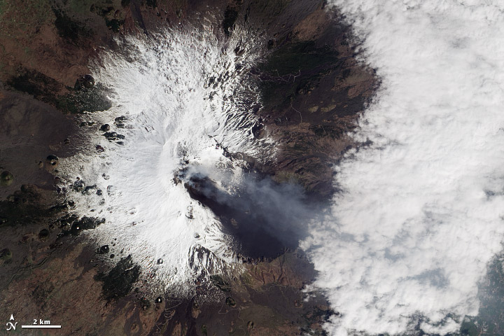
acquired March 23, 2013
download large image (3 MB, JPEG, 3400x3400)
acquired March 23, 2013
download GeoTIFF file (18 MB, TIFF)
Gas and ash stream from multiple craters on Sicily’s Mount Etna in this natural-color satellite image. Dark lava, ash, cinders, and scoria
(dense volcanic rock filled with gas bubbles) coat the southeastern
slopes. The image was collected by the Advanced Land Imager (ALI)
aboard the Earth Observing-1 (EO-1) satellite on March 23, 2013.
Related Reading
- Istituto Nazionale di Geofisica e Vulcanologia (INGV) Sezione di Catania (Italian National Institute of Geophysics and Volcanology)
NASA Earth Observatory image by Jesse Allen and Robert Simmon, using EO-1 ALI data from the NASA EO-1 team. Caption by Robert Simmon.
- Instrument:
- EO-1 - ALI
NASA: Volcanos - Savu Sea - Flores Island. Strong Eruption at Paluweh Volcano - Russia. Kamchatka Peninsula - Activity at Tolbachik - Activity at Kizimen Volcano - Italy. Etna Volcano - 27.03.13


Comments (0)
Publicar un comentario