NASA: US - Reno. Nevada at night - The Green of Central Maine - Alaska. Rocketing Into the Northern Lights - 11.03.13
Posted by Ricardo Marcenaro | Posted in NASA: US - Reno. Nevada at night - The Green of Central Maine - Alaska. Rocketing Into the Northern Lights - 11.03.13 | Posted on 19:06
Reno, Nevada, at Night

acquired February 1, 2013
download large image (830 KB, JPEG, 1440x960)
Known as “the biggest little city in
the world,” the city of Reno is located in Truckee Meadows, along the
eastern foothills of the Sierra Nevada near the California border.
It forms part of the Reno-Sparks metropolitan area—the largest such
area in northern Nevada, and the second largest in the state after Las
Vegas. Lake Tahoe,
a major destination for skiing and other outdoor recreational
activities, is located less than 50 kilometers (30 miles) to the
southwest of Reno-Sparks.
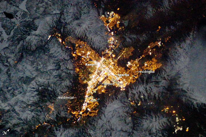
The relatively isolated nature of the city within the surrounding terrain is highlighted in this night time image taken from the International Space Station. The major industrial and commercial areas of both Reno and Sparks are brightly lit at image center. The major street grid is visible as orange linear features adjacent to the industrial/commercial areas. Residential areas appear dark in contrast. The Reno-Tahoe International Airport is visible as a dark, dagger-shaped region in the southeast quarter of the metropolitan area.
At the time this astronaut photograph was taken, the Moon was in a waning gibbous phase (98 percent of a full moon). Moonlight provided enough illumination of the ground so that the topography (accentuated by snow cover) surrounding the Reno-Sparks area is clearly visible following color enhancement.
Astronaut photograph ISS034-E-35548
was acquired on January 28, 2013, with a Nikon D3S digital camera using
a 180 millimeter lens, and is provided by the ISS Crew Earth
Observations experiment and Image Science & Analysis Laboratory,
Johnson Space Center. The image was taken by the Expedition 34 crew. It has been cropped and enhanced to improve contrast, and lens artifacts have been removed. The International Space Station Program supports the laboratory as part of the ISS National Lab
to help astronauts take pictures of Earth that will be of the greatest
value to scientists and the public, and to make those images freely
available on the Internet. Additional images taken by astronauts and
cosmonauts can be viewed at the NASA/JSC Gateway to Astronaut Photography of Earth. Caption by William L. Stefanov, Jacobs/ESCG at NASA-JSC.
- Instrument:
- ISS - Digital Camera
The Green of Central Maine

acquired April 14, 2008
download large image (1 MB, JPEG, 2523x1491)

acquired July 15, 2008
download large image (530 KB, JPEG, 2523x1491)
Today’s caption is excerpted from our new image series World of Change: Green Seasons of Maine.
The middle latitudes of Earth have seasons of weather and a wide diversity of landscapes and vegetation. But not many mid-latitude locations have year-round greenery and distinct seasons, as they do in central Maine.
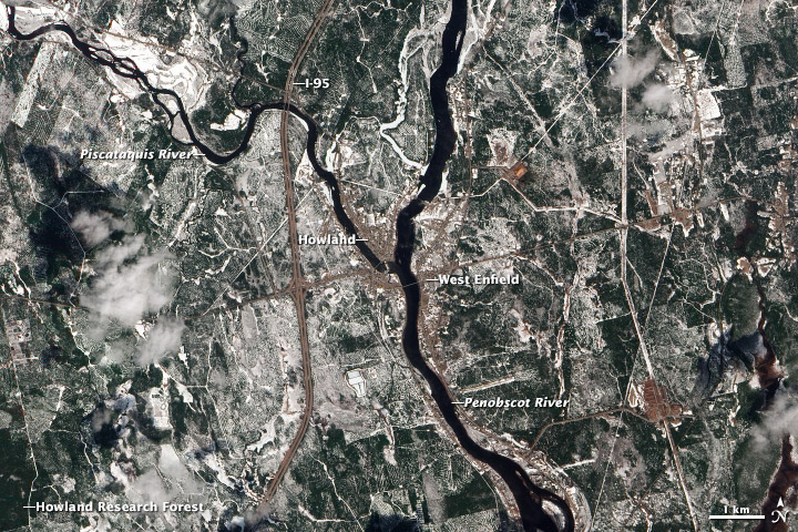
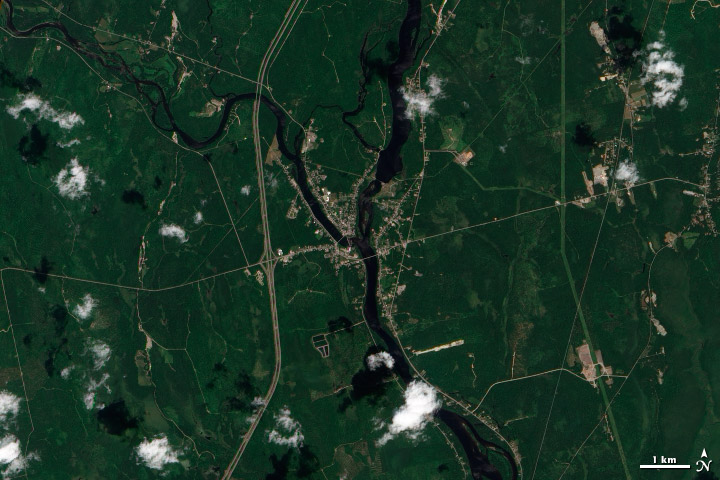
The Advanced Land Imager (ALI) on NASA’s Earth Observing-1 satellite captured these images centered on the small towns of Howland and West Enfield, Maine, on April 14 and July 15, 2008. Though spring begins on March 20, central Maine was still shedding its blanket of winter snow in mid-April, revealing brown farmland, deciduous forest, and shrubland that struggle to sprout buds in the raw springtime of New England. By July, the landscape is covered in bright green of full growth. (Visit this page to see five more images across the seasons.)
One constant in the images is the green, as Maine has the highest percentage of forest cover in the United States (about 86 percent). Central Maine lies along the transition between northeastern hardwood trees and softwood coniferous species. The area has long been a rich source of lumber, a major supplier for the United States and the world since the 19th century. Logging is still a key industry, supporting thousands of jobs in the state.
Deciduous trees, such as red oak and white ash, appear to line the rivers and streams and the residential areas shown above. But it is the evergreen trees that dominate the forest canopy, particularly spruce, cedar, hemlock, and white pine. Fir trees were once abundant, but many were wiped out in the 1960s and 70s by budworm infestations. These evergreens hold their color throughout the year and cover much of the landscape, even standing above the winter snowfall.
The patchwork of forest has been a boon to research. On a tract southwest of the towns (image lower left), the Howland Research Forest is the site of long-term scientific studies supported by NASA, the National Science Foundation, the U.S. Forest Service, the U.S. Department of Agriculture, and the U.S. Department of Energy. Researchers have observed the effects of acid rain; examined the cycling of nutrients through soils; and continually measured how much carbon dioxide the trees absorb, store, and return to the atmosphere. The Howland Forest is also a key natural laboratory for observing long-term ecosystem changes.
The Penobscot River watershed has been undergoing a renaissance in recent years, as two dams have been removed to restore habitat for salmon, bass, and other fish that have had their passage blocked for nearly two centuries. The Howland Dam (image center, at the confluence) will soon be decommissioned as well, and a fish bypass will be built.
The landscape around West Enfield and Howland is mostly flat and about 70 meters (230 feet) above sea level. The area was buried under rivers of ice during the last Ice Age. Then, when the glaciers retreated, the area was underwater until the landmass bounced back from the weight of the ice cover. Fossil shells and marine clays can still be found amidst the peat soils, glacial tills, bogs, and wetlands.
Related Reading
- Maine.gov Maine Geological Survey. Accessed February 5, 2013.
- Maine Office of Tourism The Maine Highlands. Accessed February 5, 2013.
- Penobscot River Restoration Trust Penobscot River Restoration Project. Accessed February 5, 2013.
- The Maine Highlands The Lincoln Lakes Region. Accessed February 5, 2013.
- University of Maine (1994) Forests of Maine. Accessed February 5, 2013.
- Forest Ecosystem Research at Howland Maine Site Facts and Figures. Accessed February 5, 2013.
NASA Earth Observatory images by Robert Simmon and Jesse Allen, using Advanced Land Imager data from the NASA EO-1 team. Caption by Mike Carlowicz.
- Instrument:
- EO-1 - ALI
Rocketing Into the Northern Lights

acquired February 6, 2013
download large image (524 KB, JPEG, 1600x1142)
Auroras are a visible reminder of our
planet’s connection to space. The “northern lights” and “southern
lights,” as they are more commonly known, are like a rain of highly
energized particles from the space around Earth. Provoked by storms and
winds from the Sun, electrons trapped inside Earth’s magnetic field
(magnetosphere) accelerate down toward the upper atmosphere
(ionosphere), where they smash into oxygen and nitrogen molecules and
release photons of green, red, and blue light. The light shows can take
the shape of waving curtains or rays or diffuse clouds.
At the same time that particles are raining down from space, others are leaving. The “auroral wind” is a strong but intermittent stream of oxygen atoms that flow from the atmosphere into outer space during northern lights shows. Scientists from NASA’s Goddard Space Flight Center and The Aerospace Corporation, together with the support team from the University of Alaska’s Geophysical Institute, launched a rocket from the Poker Flat Research Range to study this little-understood emission from the atmosphere. The NASA-sponsored VISIONS campaign—VISualizing Ion Outflow via Neutral atom imaging during a Substorm—was designed to fly instruments into the aurora for a fifteen-minute close-up examination.
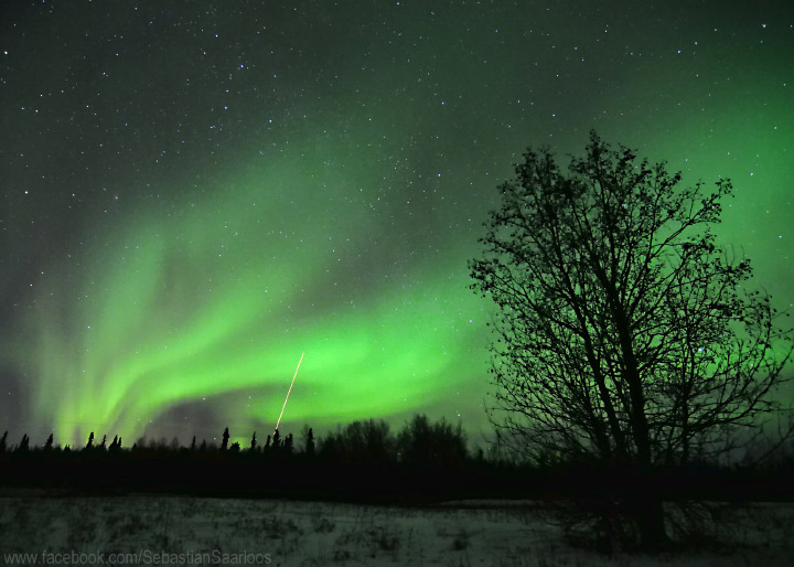
The photo above was taken by Sebastian Saarloos, an amateur photographer who was watching the launch from Delta Junction, Alaska, about 120 miles (195 kilometers) southeast from Poker Flat. He captured the image of the rocket streaking into the aurora at 11:21 p.m. local time on February 6, 2013.
Most of the atmosphere is bound by Earth’s gravity, but a small portion gets heated enough by the aurora that it can break free and flow outwards into near-Earth space. The atoms that form this wind initially travel at just 300 miles per hour—only one percent of the speed needed to overcome gravity and leave Earth's atmosphere.
“This oxygen would normally never gain enough energy to leave the atmosphere,” said Doug Rowland, principal investigator for VISIONS and a member of NASA’s Space Weather Laboratory. “On the other hand, at very high altitudes, satellite experiments have measured oxygen atoms moving faster than 50 miles per second. These experiments have shown that if oxygen can reach these high altitudes, there are plenty of ways for it to gain even more energy and escape near-Earth space entirely. What we don’t know is how the oxygen gets enough energy to fight against gravity and reach the higher altitudes where these slingshots are active.” You can observe a short video of the launch by clicking here.
Related Reading
- Carlowicz, M.J. and Hill, S. (2002) NASA Poster: Aurora—Fabled Glowing Lights of the Sun-Earth Connection. (PDF) Accessed February 8, 2013.
- Geophysical Institute, University of Alaska–Fairbanks (2013, February 7) Successful Launch From Poker Flat Research Range. Accessed February 8, 2013.
- NASA (2013, January 31) VISIONS: Seeing the Aurora in a New Light. Accessed February 8, 2013.
- NASA (2013, February 7) VISIONS: A Successful Launch. Accessed February 8, 2013.
- Instrument:
- Photograph
Photograph copyright Sebastian Saarloos.
Caption by Mike Carlowicz, Earth Observatory, and Claire De Saravia,
NASA-GSFC, with reporting from Amy Hartley, University of Alaska
Geophysical Institute.
NASA: US - Reno. Nevada at night - The Green of Central Maine - Alaska. Rocketing Into the Northern Lights - 11.03.13
Ricardo M Marcenaro - Facebook
Operative blogs of The Solitary Dog:
solitary dog sculptor:
http://byricardomarcenaro.blogspot.com
Solitary Dog Sculptor I:
http://byricardomarcenaroi.blogspot.com
Para:
comunicarse conmigo,
enviar materiales para publicar,
propuestas:
marcenaroescultor@gmail.com
For:
contact me,
submit materials for publication,
proposals:
marcenaroescultor@gmail.com
Diario La Nación
Argentina
Cuenta Comentarista en el Foro:
Capiscum
My blogs are an open house to all cultures, religions and countries. Be a follower if you like it, with this action you are building a new culture of tolerance, open mind and heart for peace, love and human respect.
Thanks :)
Mis blogs son una casa abierta a todas las culturas, religiones y países. Se un seguidor si quieres, con esta acción usted está construyendo una nueva cultura de la tolerancia, la mente y el corazón abiertos para la paz, el amor y el respeto humano.
Gracias :)


Comments (0)
Publicar un comentario