NASA: US - Eastern Pacific Ocean area - Hurricane Daniel - Mexico US: Hurricane Emilia - 09.07.12
Posted by Ricardo Marcenaro | Posted in NASA: US - Eastern Pacific Ocean area - Hurricane Daniel - Mexico US: Hurricane Emilia - 09.07.12 | Posted on 16:12

acquired July 8, 2012
download large image (7 MB, JPEG, 6000x7800)
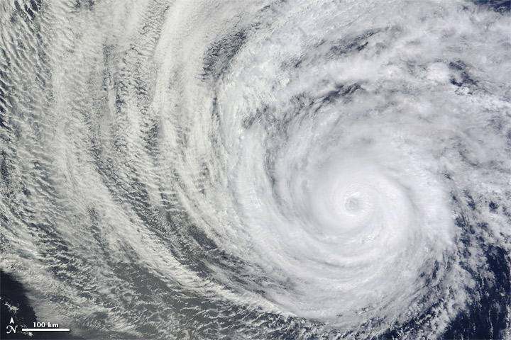
In early July 2012, two simultaneous hurricanes blew over the eastern Pacific Ocean: Hurricane Emilia
and Hurricane Daniel. The first of the two storms to form, Daniel
started as a tropical depression on July 4. The storm had strengthened
to a Category 2 hurricane by 12:20 p.m. Pacific Daylight Time on July 8,
when the Moderate Resolution Imaging Spectroradiometer (MODIS) on NASA’s Terra
satellite captured this natural-color image. By that time, Daniel
sported a distinct eye characteristic of hurricanes, and its spiral arms
spanned hundreds of kilometers over the open ocean.
At 2:00 p.m. PDT on July 8, not long after MODIS acquired this image, the U.S. National Hurricane Center (NHC) reported that Daniel was located roughly 1,120 miles (1,800 kilometers) west-southwest of the southern tip of Baja California. The storm had maximum sustained winds of 105 miles (165 kilometers) per hour.
By the following day, Daniel had weakened, though it remained a hurricane. At 8:00 a.m. PDT on July 9, Daniel had moved farther away from Baja California, and the storm’s wind speeds had dropped to 85 miles (140 kilometers) per hour. No hazards affected land as of July 9, the NHC reported, and Daniel was expected to weaken further as it continued moving westward.
Though the storm posed no threat to Mexico, it had the potential to bring unsettled weather to Hawaii. Daniel’s remnants were expected to pass south of the island chain around July 13, 2012, AccuWeather reported. Remnants of the storm might cause gusty winds, heavy rains, and even localized flash flooding.
-
References
- National Hurricane Center. (2012, July 9) Hurricane Advisory Archive. Accessed July 9, 2012.
- Edwards, B. (2012, July 9) Hurricane Daniel could impact Hawaii by late week. AccuWeather. Accessed July 9, 2012.
NASA image courtesy Jeff Schmaltz, LANCE MODIS Rapid Response Team, Goddard Space Flight Center. Caption by Michon Scott.
- Instrument:
- Terra - MODIS

acquired July 8, 2012
download large image (8 MB, JPEG, 6400x8400)
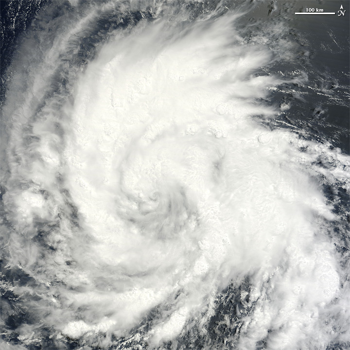
As Daniel
weakened over the eastern Pacific in early July 2012, Emilia
strengthened. Emilia formed as a tropical depression on July 7, and
within two days intensified to a Category 1 hurricane, the U.S. National
Hurricane Center (NHC) reported. As of 2:00 a.m. Pacific Daylight Time
on July 9, Emilia was located roughly 760 miles (1,225 kilometers) south
of the southern tip of Baja California, with maximum sustained winds of
75 miles (120 kilometers) per hour.
Emilia was still a tropical storm when the Moderate Resolution Imaging Spectroradiometer (MODIS) on NASA’s Terra satellite captured this natural-color image at 10:45 a.m. PDT on July 8. The storm had maximum sustained winds of 65 miles (100 kilometers) per hour, and was headed west-northwest, the NHC reported.
The NHC forecast that Emilia could become a major hurricane by July 10 as it continued moving westward over the Pacific Ocean. As of July 9, however, it posed no hazards to land.
-
References
- National Hurricane Center. (2012, July 9) Hurricane Advisory Archive. Accessed July 9, 2012.
NASA image courtesy Jeff Schmaltz, LANCE MODIS Rapid Response Team, Goddard Space Flight Center. Caption by Michon Scott.
- Instrument:
- Terra - MODIS
NASA: US - Eastern Pacific Ocean area - Hurricane Daniel - Mexico US: Hurricane Emilia - 09.07.12
Ricardo M Marcenaro - Facebook
Operative blogs of The Solitary Dog:
solitary dog sculptor:
http://byricardomarcenaro.blogspot.com
Solitary Dog Sculptor I:
http://byricardomarcenaroi.blogspot.com
Para:
comunicarse conmigo,
enviar materiales para publicar,
propuestas:
marcenaroescultor@gmail.com
For:
contact me,
submit materials for publication,
proposals:
marcenaroescultor@gmail.com
Diario La Nación
Argentina
Cuenta Comentarista en el Foro:
Capiscum
My blogs are an open house to all cultures, religions and countries. Be a follower if you like it, with this action you are building a new culture of tolerance, open mind and heart for peace, love and human respect.
Thanks :)
Mis blogs son una casa abierta a todas las culturas, religiones y países. Se un seguidor si quieres, con esta acción usted está construyendo una nueva cultura de la tolerancia, la mente y el corazón abiertos para la paz, el amor y el respeto humano.
Gracias :)


Comments (0)
Publicar un comentario